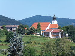
Grafling
municipality of Germany
Grafling is a municipality in the district of Deggendorf in Bavaria in Germany.
Grafling | |
|---|---|
 Saint Andrew Church | |
| Coordinates: 48°54′N 12°59′E / 48.900°N 12.983°E | |
| Country | Germany |
| State | Bavaria |
| Admin. region | Niederbayern |
| District | Deggendorf |
| Government | |
| • Mayor (2020–26) | Anton Stettmer[1] (CSU) |
| Area | |
| • Total | 46.28 km2 (17.87 sq mi) |
| Elevation | 433 m (1,421 ft) |
| Population (2022-12-31)[2] | |
| • Total | 2,748 |
| • Density | 59/km2 (150/sq mi) |
| Time zone | UTC+01:00 (CET) |
| • Summer (DST) | UTC+02:00 (CEST) |
| Postal codes | 94539 |
| Dialling codes | 0991 |
| Vehicle registration | DEG |
| Website | www.grafling.de |
Geography
changeGrafling is in the Danube Forest Planning Region (Planungsregion Donau-Wald). Its lowest point is in Großtiefenbach at 326 m above sea level (NN). The highest points of the municipality are the Steinberg (999 m), the Geißriegel (1,043 m), the Dreitannenriegel (1,090 m) and the Einödriegel (1,121 m) which rise above the valley of the Graflinger Tal to the east. To the north the valley ends at the Hochberg (727 m), to the west it is guarded by the Butzen (775 m) and the Vogelsang (1,022 m) in the municipality of Bernried. To the south the valley opens up towards Deggendorf, the Danube Plain, and the Gäuboden.
References
change- ↑ Liste der ersten Bürgermeister/Oberbürgermeister in kreisangehörigen Gemeinden, Bayerisches Landesamt für Statistik, 15 July 2021.
- ↑ Genesis Online-Datenbank des Bayerischen Landesamtes für Statistik Tabelle 12411-003r Fortschreibung des Bevölkerungsstandes: Gemeinden, Stichtag (Einwohnerzahlen auf Grundlage des Zensus 2011) .


