Hattingen
town in the district of Ennepe-Ruhr-Kreis, in North Rhine-Westphalia, Germany
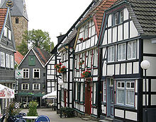
Hattingen an der Ruhr is a city about 60,000 people in the state of North Rhine-Westphalia in Germany. It belongs to the Ruhr area. It is south of Bochum and Essen. Very famous is its Altstadt.
Hattingen | |
|---|---|
| Coordinates: 51°23′57″N 7°11′09″E / 51.39917°N 7.18583°E | |
| Country | Germany |
| State | North Rhine-Westphalia |
| Admin. region | Arnsberg |
| District | Ennepe-Ruhr-Kreis |
| Government | |
| • Mayor | Dr. Dagmar Goch (SPD) |
| Area | |
| • Total | 71.40 km2 (27.57 sq mi) |
| Highest elevation | 306 m (1,004 ft) |
| Lowest elevation | 60 m (200 ft) |
| Population (2022-12-31)[1] | |
| • Total | 54,637 |
| • Density | 770/km2 (2,000/sq mi) |
| Time zone | UTC+01:00 (CET) |
| • Summer (DST) | UTC+02:00 (CEST) |
| Postal codes | 45525 – 45527 – 45529 |
| Dialling codes | 02324 |
| Vehicle registration | EN |
| Website | www |

References
changeOther websites
changeMedia related to Hattingen at Wikimedia Commons


