Lancaster, Kansas
Lancaster is a city in Atchison County, Kansas, United States. In 2020, 246 people lived there.[3]
Lancaster, Kansas | |
|---|---|
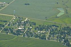
 Aerial view of Lancaster (2013) | |
 Location within Atchison County and Kansas | |
 | |
| Coordinates: 39°34′16″N 95°18′13″W / 39.57111°N 95.30361°W[1] | |
| Country | United States |
| State | Kansas |
| County | Atchison |
| Township | Lancaster |
| Founded | 1850s |
| Platted | 1857 |
| Named for | Lancaster, Pennsylvania |
| Area | |
| • Total | 0.20 sq mi (0.52 km2) |
| • Land | 0.20 sq mi (0.52 km2) |
| • Water | 0.00 sq mi (0.00 km2) |
| Elevation | 1,161 ft (354 m) |
| Population | |
| • Total | 246 |
| • Density | 1,200/sq mi (470/km2) |
| Time zone | UTC−6 (CST) |
| • Summer (DST) | UTC−5 (CDT) |
| ZIP Code | 66041 |
| Area code | 913 |
| FIPS code | 20-38325 |
| GNIS ID | 2395625[1] |
History
changeLancaster was platted in 1857.[4] It may have been named after Lancaster, Pennsylvania.[5] Lancaster was an early contender for county seat.[6] In 1915, Lancaster had seven stores, a school, three churches, a grain elevator, a lumber yard, and a hotel.[7]
Lancaster was a station on the Missouri Pacific Railroad.[8]
Geography
changeLancaster is at 39°34′16″N 95°18′13″W / 39.57111°N 95.30361°W (39.571159, -95.303712).
According to the United States Census Bureau says that the city has a total area of 0.20 square miles (0.52 km2). All of it is land.[2]
Demographics
change| Historical population | |||
|---|---|---|---|
| Census | Pop. | %± | |
| 1900 | 292 | — | |
| 1910 | 220 | −24.7% | |
| 1920 | 184 | −16.4% | |
| 1930 | 188 | 2.2% | |
| 1940 | 163 | −13.3% | |
| 1950 | 200 | 22.7% | |
| 1960 | 196 | −2.0% | |
| 1970 | 279 | 42.3% | |
| 1980 | 274 | −1.8% | |
| 1990 | 299 | 9.1% | |
| 2000 | 291 | −2.7% | |
| 2010 | 298 | 2.4% | |
| 2020 | 246 | −17.4% | |
| U.S. Decennial Census | |||
2020 census
changeAs of the 2020 census, there were 246 people, 109 households, and 73 families living in the city. Of the households, 83.5% owned their home and 16.5% rented their home.
The median age was 43.6 years. Of the people, 96.3% were White and 3.7% were two or more races. Hispanic or Latino of any race were 1.6% of the people.[3][9]
2010 census
changeAs of the 2010 census says that there were 298 people, 108 households, and 87 families living in the city.[10]
References
change- ↑ 1.0 1.1 1.2 U.S. Geological Survey Geographic Names Information System: Lancaster, Kansas
- ↑ 2.0 2.1 "2020 U.S. Gazetteer Files". United States Census Bureau. Retrieved November 19, 2023.
- ↑ 3.0 3.1 3.2 "DP1: PROFILE OF GENERAL POPULATION AND HOUSING CHARACTERISTICS". United States Census Bureau. Retrieved November 19, 2023.
- ↑ Blackmar, Frank Wilson (1912). Kansas: A Cyclopedia of State History, Volume 2. Standard Publishing Company. p. 94.
- ↑ "Profile for Lancaster, Kansas". ePodunk. Archived from the original on 6 June 2014. Retrieved 4 June 2014.
- ↑ History of the State of Kansas: Containing a Full Account of Its Growth from an Uninhabited Territory to a Wealthy and Important State. A. T. Andreas. 1883. p. 409.
- ↑ Ingalls, Sheffield (1916). History of Atchison County, Kansas. Standard Publishing Company. p. 96.
- ↑ Gannett, Henry (1898). A Gazetteer of Kansas. Govt. Print. Off. p. 128.
- ↑ "P16: HOUSEHOLD TYPE". United States Census Bureau. Retrieved December 31, 2023.
- ↑ "American FactFinder". United States Census Bureau. Retrieved 2012-07-06.
Other websites
change- City
- Schools
- USD 377, local school district
- Maps
- Lancaster City Map, KDOT