Langon, Gironde
Langon (Gascon: Lengon) is a commune in the Gironde department in Nouvelle-Aquitaine region in southwestern France. It is one of the five sub-prefectures of the department.
Langon | |
|---|---|
Subprefecture and commune | |
 Langon and the Garonne. | |
.svg) Coat of arms | |
Location of Langon  | |
 Langon  Langon | |
| Coordinates: 44°33′14″N 0°14′54″W / 44.5538888889°N 0.248333333333°W | |
| Country | France |
| Region | Nouvelle-Aquitaine |
| Department | Gironde |
| Arrondissement | Langon |
| Canton | Le Sud-Gironde |
| Intercommunality | Le Sud Gironde |
| Government | |
| • Mayor (2014–2020) | Philippe Plagnol[1] |
| Area 1 | 13.71 km2 (5.29 sq mi) |
| Population (2014) | 7,396 |
| • Density | 540/km2 (1,400/sq mi) |
| Demonym | Langonnais |
| Time zone | UTC+01:00 (CET) |
| • Summer (DST) | UTC+02:00 (CEST) |
| INSEE/Postal code | 33227 /33210 |
| Elevation | 0–73 m (0–240 ft) (avg. 37 m or 121 ft) |
| Website | www.langon33.fr |
| 1 French Land Register data, which excludes lakes, ponds, glaciers > 1 km2 (0.386 sq mi or 247 acres) and river estuaries. | |
Geography
changeLangon is in the southeastern part of the department 48 km (30 mi) to the southeast of Bordeaux. The city is on the left side of the Garonne river, near the border between the Graves wine region and the Landes forest.
The commune has an area of 13.7 km2 (5.3 sq mi),[2] and its average altitude is 37 m (121 ft); at the city hall, the altitude is 20 m (66 ft).[3]

|
The commune is surrounded by the communes Saint-Pierre-de-Mons to the east, Coimères to the southeast, Mazères to the south, Roaillan to the southwest, Fargues to the west and Toulenne to the northwest. Across the Garonne river are Saint-Maixant to the north and Saint-Macaire to the northeast.
Climate
changeThe climate of Langon is Marine West Coast Climate (Köppen climate classification: Cfb), with mild winters and warm summers.
Population
changeThe inhabitants of Langon are known, in French, as Langonnais (women: Langonnaises).[4]
With a population of 7,396,[5] Langon has a population density of 539 inhabitants/km2.
Evolution of the population in Langon

Administration
changeLangon is a sub-prefecture of the Gironde department. It is also the capital of the arrondissement of Langon and the administrative centre (French: chef-lieu) of the canton of Le Sud-Gironde with 39,445 inhabitants (2014).[6]
It is part of the intercommunality Le Sud Gironde (French: Communauté de communes du Sud Gironde).
Twin towns
changeGallery
change-
 Downtown Langon.
 -
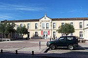
 Sub-prefecture.
 -
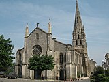 Saint-Gervais church
 -
 Les Carmes cultural centre.


Related pages
changeReferences
change- ↑ "Le Conseil Municipal" (in French). Ville de Langon. Retrieved 18 May 2017.
- ↑ "Commune de Langon (33227)". Comparateur de territoire (in French). Institut national de la statistique et des études économiques - INSEE. Retrieved 18 May 2017.
- ↑ "Langon". Map-France.com. Retrieved 18 May 2017.
- ↑ "Gironde" (in French). habitants.fr. Retrieved 18 May 2017.
- ↑ "Régions, départements, arrondissements, cantons et communes" (PDF). Populations légales 2014 (in French). Institut national de la statistique et des études économiques - INSEE. Retrieved 18 May 2017.
- ↑ "Commune de Langon (33227)". Géographie administrative et d’étude (in French). Institut national de la statistique et des études économiques - INSEE. Retrieved 18 May 2017.
- ↑ "Jumelage" (in French). Ville de Langon. Retrieved 18 May 2017.
Other websites
change- Ville de Lesparre-Médoc - Official site (in French)
- Departamental Council of Gironde Archived 2008-03-29 at the Wayback Machine (in French)
- Prefecture official website (in French)
- Agence de Développement Touristique de la Gironde Archived 2011-02-04 at the Wayback Machine (in French)
- Région Nouvelle-Aquitaine (in French)