Marion County, Ohio
Marion County is a county in the U.S. state of Ohio. In 2020, 65,359 people lived there.[1] The county seat is Marion.[2]
Marion County | |
|---|---|
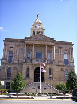
 Marion County Courthouse | |
 Location within the U.S. state of Ohio | |
 Ohio's location within the U.S. | |
| Coordinates: 40°35′N 83°10′W / 40.59°N 83.16°W | |
| Country | |
| State | |
| Founded | May 1, 1824 |
| Named for | Francis Marion |
| Seat | Marion |
| Largest city | Marion |
| Area | |
| • Total | 404 sq mi (1,050 km2) |
| • Land | 404 sq mi (1,050 km2) |
| • Water | 0.4 sq mi (1 km2) 0.1% |
| Population (2020) | |
| • Total | 65,359 |
| • Density | 160/sq mi (62/km2) |
| Time zone | UTC−5 (Eastern) |
| • Summer (DST) | UTC−4 (EDT) |
| Congressional district | 4th |
| Website | www |
History
changeThe county was founded on May 1, 1824[3] and is named for General Francis "The Swamp Fox" Marion, a South Carolinian officer in the Revolutionary War.[4]
Geography
changeThe U.S. Census Bureau says that the county has a total area of 404 square miles (1,050 km2). Of that 404 square miles (1,050 km2) is land and 0.4 square miles (1.0 km2) (0.1%) is water.[5] It is the fifth-smallest county in Ohio by total area.
Bordering counties
change- Crawford County (northeast)
- Morrow County (east)
- Delaware County (south)
- Union County (southwest)
- Hardin County (west)
- Wyandot County (northwest)
Demographics
change| Historical population | |||
|---|---|---|---|
| Census | Pop. | %± | |
| 1830 | 6,551 | — | |
| 1840 | 14,765 | 125.4% | |
| 1850 | 12,618 | −14.5% | |
| 1860 | 15,490 | 22.8% | |
| 1870 | 16,184 | 4.5% | |
| 1880 | 20,565 | 27.1% | |
| 1890 | 24,727 | 20.2% | |
| 1900 | 28,678 | 16.0% | |
| 1910 | 33,971 | 18.5% | |
| 1920 | 42,004 | 23.6% | |
| 1930 | 45,420 | 8.1% | |
| 1940 | 44,898 | −1.1% | |
| 1950 | 49,959 | 11.3% | |
| 1960 | 60,221 | 20.5% | |
| 1970 | 64,724 | 7.5% | |
| 1980 | 67,974 | 5.0% | |
| 1990 | 64,274 | −5.4% | |
| 2000 | 66,217 | 3.0% | |
| 2010 | 66,501 | 0.4% | |
| 2020 | 65,359 | −1.7% | |
| U.S. Decennial Census[6] 1790-1960[7] 1900-1990[8] 1990-2000[9] 2010-2020[1] | |||
2020 census
changeThe 2020 United States Census says that there were 65,359 people, 24,932 households, and 16,035 families living in the county.[1][10]
2010 census
changeThe 2010 United States Census says that there were 66,501 people, 24,691 households, and 16,837 families living in the county.[11]
Communities
changeCity
change- Marion (county seat)
Villages
changeTownships
change- Big Island
- Bowling Green
- Claridon
- Grand
- Grand Prairie
- Green Camp
- Marion
- Montgomery
- Pleasant
- Prospect
- Richland
- Salt Rock
- Scott
- Tully
- Waldo
Unincorporated communities
change- Bellaire Gardens
- Big Island
- Brush Ridge
- Centerville
- Claridon
- DeCliff
- Espyville
- Gast Corner
- Kirkpatrick
- Lynn
- Martel
- Meeker
- Oak Knoll
- Owens
- Tobias
References
change- ↑ 1.0 1.1 1.2 "QuickFacts: Marion County, Ohio". United States Census Bureau. Retrieved January 18, 2024.
- ↑ "Find a County". National Association of Counties. Retrieved 2011-06-07.
- ↑ "Ohio: Individual County Chronologies". Ohio Atlas of Historical County Boundaries. The Newberry Library. 2007. Archived from the original on April 6, 2016. Retrieved February 14, 2015.
- ↑ Gannett, Henry (1905). The Origin of Certain Place Names in the United States. U.S. Government Printing Office. p. 200.
- ↑ "2010 Census Gazetteer Files". United States Census Bureau. August 22, 2012. Archived from the original on May 4, 2014. Retrieved February 9, 2015.
- ↑ "U.S. Decennial Census". United States Census Bureau. Retrieved February 9, 2015.
- ↑ "Historical Census Browser". University of Virginia Library. Retrieved February 9, 2015.
- ↑ Forstall, Richard L., ed. (March 27, 1995). "Population of Counties by Decennial Census: 1900 to 1990". United States Census Bureau. Retrieved February 9, 2015.
- ↑ "Census 2000 PHC-T-4. Ranking Tables for Counties: 1990 and 2000" (PDF). United States Census Bureau. April 2, 2001. Archived (PDF) from the original on 2010-03-27. Retrieved February 9, 2015.
- ↑ "P16: HOUSEHOLD TYPE". United States Census Bureau. Retrieved January 2, 2024.
- ↑ "DP-1 Profile of General Population and Housing Characteristics: 2010 Demographic Profile Data". United States Census Bureau. Archived from the original on 2020-02-13. Retrieved 2015-12-27.

