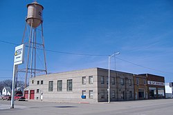
Ocheyedan, Iowa
human settlement in Osceola County, Iowa, United States of America
Ocheyedan is a city in Iowa in the United States. It is in Osceola County.
Ocheyedan, Iowa | |
|---|---|
 | |
 Location of Ocheyedan, Iowa | |
| Coordinates: 43°24′52″N 95°32′7″W / 43.41444°N 95.53528°W | |
| Country | |
| State | |
| County | Osceola |
| Area | |
| • Total | 1.13 sq mi (2.93 km2) |
| • Land | 1.13 sq mi (2.93 km2) |
| • Water | 0.00 sq mi (0.00 km2) |
| Elevation | 1,575 ft (480 m) |
| Population | |
| • Total | 439 |
| • Density | 387.81/sq mi (149.76/km2) |
| Time zone | UTC-6 (Central (CST)) |
| • Summer (DST) | UTC-5 (CDT) |
| ZIP codes | 51349, 51354 |
| Area code | 712 |
| FIPS code | 19-58530 |
| GNIS feature ID | 0459794 |
References
change- ↑ "2020 U.S. Gazetteer Files". United States Census Bureau. Retrieved March 16, 2022.
- ↑ "Ocheyedan city, Iowa". United States Census Bureau. Retrieved November 8, 2023.