Quedlinburg
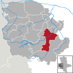
Quedlinburg (German pronunciation: [ˈkveːtlɪnbʊʁk]); Low Saxon: Queddelnborg) is a city in the state of Saxony-Anhalt, Germany. Its area is 78 square kilometres (30.1 square miles). 22,795 people lived there in 2005. Quedlinburg is 8 kilometres (5.0 miles) north of the Harz mountains. A small river called Bode flows through the city. In 1994, UNESCO added the old town Quedlinburg on the list of World Heritage Sites.
Quedlinburg | |
|---|---|
 Quedlinburg castle hill | |
| Coordinates: 51°47′30″N 11°8′50″E / 51.79167°N 11.14722°E | |
| Country | Germany |
| State | Saxony-Anhalt |
| District | Harz |
| Subdivisions | 7 Stadtteile |
| Government | |
| • Mayor | Frank Ruch (CDU) |
| Area | |
| • Total | 120.42 km2 (46.49 sq mi) |
| Elevation | 123 m (404 ft) |
| Population (2021-12-31)[1] | |
| • Total | 23,341 |
| • Density | 190/km2 (500/sq mi) |
| Time zone | UTC+01:00 (CET) |
| • Summer (DST) | UTC+02:00 (CEST) |
| Postal codes | 06484, 06485 |
| Dialling codes | 03946, 039485 |
| Vehicle registration | HZ, HBS, QLB, WR |
| Website | www |
| UNESCO World Heritage Site | |
|---|---|
 South of the castle hill: Schlossmühle | |
| Criteria | Cultural: iv |
| Reference | 535 |
| Inscription | 1994 (18th Session) |
| Area | 90 ha |
| Buffer zone | 270 ha |
History
changeIn the year 922 the name Quedlinburg was first mentioned in a paper from King Henry I the Fowler of Germany. In the first half of the 10th century the Hungarians with their horses attacked many places all over central Europe. King Henry built up a castle to give the farmers around a place to hide. In 936 the king died and his body was buried on the castle hill in Quedlinburg. His widow, Matilda, and his son, King Otto I, set up a convent for ladies. The tasks of this convent included the commemoration of King Henry I and the education of young ladies to get better chances to get married. This convent on the hill was dissolved in 1803. First abbess of the ladies-convent was Matilda, the daughter of King Otto I and granddaughter of Queen Matilda. In the valley north of that hill in 994 King Otto III founded the old town. He was asked to do so by his aunt abbess Matilda.
This old town was used by merchants to sell and buy textiles and so it grew larger. In the middle of the 12th century a new town was created by the abbess of the ladies-convent. In 1330 both towns were united. They got stronger in power and in 1477 they tried to get totally independent of the abbess. But military troops sent by the brothers of the abbess occupied both towns. All the citizens got under control of the abbess again. In 1541 the Protestant Reformation reached the convent and the town and everybody changed their beliefs to the Protestant religion. Surprisingly during the Thirty Years' War the town was not destroyed because the abbess made diplomatic arrangements with all the bypassing military leaders.
Geography and Climate
changeThe city is 8 kilometres (5.0 miles) north of the Harz mountains around 123 metres (404 feet) above sea water level . The nearby mountains reached about 180 metres (590 feet) above sea level. Most of the town is on the western side of the river Bode's bank. The town area covers around 78,15 square kilometers.
The average temperature of the year is 8,8 °C. January and February are the coldest months of the year, with an average temperature of 0,1 °C and 0,4 °C. July and August are the hottest months, with an average temperature of 17,8 °C (63 °F) and 17,2 °C. The average annual rainfall is about 438 millimetres. The rainfall occurs usually between May and September. Rain in Quedlinburg is among the lowest in Germany, which has an annual average around 800 millimetres.
Sister cities
changeQuedlinburg has partnerships with 5 cities. Each of the 5 boroughs also has their sister cities, sometimes called twin towns.
|
References
change- ↑ "Bevölkerung der Gemeinden – Stand: 31. Dezember 2021" (PDF) (in German). Statistisches Landesamt Sachsen-Anhalt. June 2022.
Other websites
changeMedia related to Quedlinburg at Wikimedia Commons
- Official page
- Private homepage (in English) Archived 2013-05-21 at the Wayback Machine


