Saint-Flour, Cantal
Saint-Flour (Occitan: Sant Flor) is a commune in south central France in the region of Auvergne-Rhône-Alpes. It is a subprefecture of the Cantal department. It is also the capital of the arrondissement of the same name.
Saint-Flour | |
|---|---|
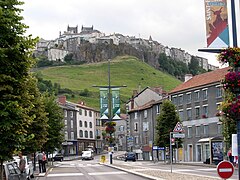
 Saint-Flour - the lower town | |
.svg) Coat of arms | |
Location of Saint-Flour  | |
 Saint-Flour  Saint-Flour | |
| Coordinates: 45°02′04″N 3°05′37″E / 45.0344°N 3.0936°E | |
| Country | France |
| Region | Auvergne-Rhône-Alpes |
| Department | Cantal |
| Arrondissement | Saint-Flour |
| Canton | Capital of 2 cantons |
| Intercommunality | Saint-Flour Communauté |
| Government | |
| • Mayor (2014-2020) | Pierre Jarlier[1] |
| Area 1 | 27.14 km2 (10.48 sq mi) |
| Population (2014) | 6,643 |
| • Density | 240/km2 (630/sq mi) |
| Demonym | Sanflorain |
| Time zone | UTC+01:00 (CET) |
| • Summer (DST) | UTC+02:00 (CEST) |
| INSEE/Postal code | 15187 /15100 |
| Elevation | 757–1,040 m (2,484–3,412 ft) (avg. 783 m or 2,569 ft) |
| Website | www.saint-flour.fr |
| 1 French Land Register data, which excludes lakes, ponds, glaciers > 1 km2 (0.386 sq mi or 247 acres) and river estuaries. | |
History
changeSaint-Flour is the historical capital of the old region of Haute-Auverge ("Upper Auvergne"), one of the two divisions of Auvergne.
After the creation of the Cantal department on 4 March 1790, Saint-Flour was named as the capital (prefecture) of the new department alternating with Aurillac. In 1794, Saint-Flour became the only capital but, in 1795, the capital was moved to Aurillac and Saint-Flour became a subprefecture.
Geography
changeSaint-Flour is in the eastern part of Cantal. The city is divided in two parts:
- The upper city (French: Ville haute) is on a volcanic dike
- The lower city (French: Ville basse) is on the sides of the Ander river, a right tributary of the Truyère river.
The commune of Saint-Flour has an area of 27.14 km2 (10.48 sq mi) and is surrounded by the communes Alleuze, Andelat, Coren, Roffiac, Saint-Georges and Villedieu.

|
Climate
changeThe climate of Saint-Flour, in the Köppen climate classification, is Cfb - Oceanic climate with template summers.[2]
Population
changeThe inhabitants of Saint-Flour are known, in French, as Sanflorain (women: Sainfloraine).[3]
With a population of 6,643,[4] Saint-Flour has a population density of 245 inhabitants/km2.
Evolution of the population in Saint-Flour

Saint-Flour forms the urban area of Saint-Flour, one of the seven urban areas of Cantal, with a population of 6,626 inhabitants (2013) and an area of 2,711 km2 (1,047 sq mi).[5] This urban area is the centre of the metropolitan area of Saint-Flour, formed by 17 communes with a population of 13,024 inhabitants and an area of 326.8 km2 (126.2 sq mi).[6]
Administration
changeSaint-Flour is a subprefecture of the Cantal department, the capital of the arrondissement of Saint-Flour and the administrative centre (French: chef-lieu) of three cantons:
- Saint-Flour-1 : 23 communes + part of Saint-Flour, with 9,696 inhabitants (2014)
- Saint-Flour-2 : 18 communes + part of Saint-Flour, with 9,171 inhabitants (2014)
It is part of the intercommunality Saint-Flour Communauté.
Sister cities
changeSaint-Flour is twinned with:
Gallery
change-
 Aerial view of the upper town, Saint-Flour
 -
 The Saint-Pierre cathedral of Saint-Flour
 -
 Saint-Flour
 -
 Lycée Notre-Dame de Saint-Flour


_Dscn0354-zh.jpg)

Related pages
changeReferences
change- ↑ "Vos élus" (in French). Ville de Saint-Flour. Retrieved 26 January 2017.
- ↑ Cite error: The named reference
mairiewas used but no text was provided for refs named (see the help page). - ↑ "Saint-Flour (15100)" (in French). habitants.fr. Retrieved 26 January 2017.
- ↑ "Régions, départements, arrondissements, cantons et communes" (PDF). Populations légales 2014 (in French). Institut national de la statistique et des études économiques - INSEE. Retrieved 26 January 2017.
- ↑ "Unité urbaine de Saint-Flour (15201)". Comparateur de territoire (in French). Institut national de la statistique et des études économiques - INSEE. Retrieved 26 January 2017.
- ↑ "Aire urbaine de Saint-Flour (328)". Comparateur de territoire (in French). Institut national de la statistique et des études économiques - INSEE. Retrieved 26 January 2017.
- ↑ "Jumelage Orléans / Saint-Flour" (in French). Ville de Saint-Flour. Archived from the original on 19 June 2017. Retrieved 26 January 2017.
- ↑ "Jumelage Haselünne / Saint-Flour" (in French). Ville de Saint-Flour. Retrieved 26 January 2017.
Other websites
change- City Council website (in French)
- Office de Tourisme Intercommunautaire des Pays de Saint-Flour Archived 2017-02-10 at the Wayback Machine (in French)