Shiogama
Shiogama (塩竈市, Shiogama-shi) is a city in Miyagi Prefecture, Japan. The city was seriously affected by the 2011 Tōhoku earthquake and tsunami. However, between 1 March and 31 August 2011, less than 1% of the people left the city.[1]
Shiogama
塩竈市 | |
|---|---|
 Urato islands Shiogama Port, Shiogama Shrine Aeon Town Shiogama, Shiogama Port Festival | |
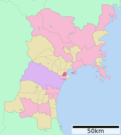
 Location of Shiogama in Miyagi Prefecture | |
| Coordinates: 38°18′51.7″N 141°01′19.1″E / 38.314361°N 141.021972°E | |
| Country | Japan |
| Region | Tōhoku |
| Prefecture | Miyagi |
| Area | |
| • Total | 17.37 km2 (6.71 sq mi) |
| Population (June 30, 2017) | |
| • Total | 54,926 |
| • Density | 3,162/km2 (8,190/sq mi) |
| Time zone | UTC+9 (Japan Standard Time) |
| - Tree | Shiogama Sakura |
| - Flower | White Chrysanthemum |
| Phone number | 022-364-1111 |
| Address | 1-1 Asahimachi, Shiogama-shi, Miyagi-ken 985-8501 |
| Website | http://www.city.shiogama.miyagi.jp/ |
Geography
changeShiogama is in the central part of Miyagi Prefecture. It is between Sendai and Matsushima. The city is surrounded by water and mountains: Matsushima Bay is on one side and Matsushima Hills on the other.
The flat areas of the city are mainly reclaimed land. About 60 percent of the urban area is on reclaimed land and 40 percent on hills. People living in the town are crowded into a narrow area. Not much land is good for stripmalls.
Writing the name of the city
changeThe Japanese language has several writing systems. One of them is kanji. Different kanji may have the same pronunciation. Some kanji are similar in form and meaning. There are two ways to write the name of the city. Both ways have the basic meaning "a pot for boiling salt". Both sound the same, but have slightly different meanings.
One way is to write 塩釜. The other way is 塩竈. The first way to write the city name is often used, such as on the post office, train station, many brand names, and on signs.
The second way comes from the history and an important landmark in the city. Shiogama shrine is at the top of a hill in the city. It is an important Shinto shrine in the Tohoku region. The city got its name from the shrine, but the shrine is written 鹽竈神社. The first character, 鹽, is an old character for salt. It has been replaced in the list of kanji for general use by a simpler character, 塩. The second character, 竈, or kamado/kama, means a large cooking area made of earth. The newer name uses 釜, which means an iron pot.
Transportation
changeTrain stations
changeMajor roads
change- National Highways
- Miyagi Prefectural Highways
- 3 Shiogama—Yoshioka
- 10 Shiogama—Watari
- 11 Shiogama-kō (Shiogama—Shiogama-kō)
- 23 Sendai—Shiogama
- 35 Izumi—Shigoama
- 58 Shiogama—Shichigahama—Tagajō
Culture
changeFestivals
change- Shiogama 'Hote' festival (10 March)
- Shiogama Flower festival and Shiogama Citizens Festival (late April)
- Shiogama Harbor festival (Eve:before Marine Day/festival:Marine Day July)
Visitor attractions
change
|
|
Notable people from Shiogama
change- Kōnosuke Fuji (Lyricist)
- Miyuki Hatanaka (Mogul skiier)
- Itaru Hirama (Photographer)
- Masao Maruyama (Anime producer)
- Takemasa Moriya (Defense vice president)
- Katsuichi Nagai (First editor-in-chief of Garo)
- Makoto Nakahara (Japanese chess player)
- Kōhei Ōtomo (Musician for "HOUND DOG")
- Tadashi Satō (Mangaka)
- Hitomi Takahashi (Singer)
- Sū Wakai (Author)
- Nobunaga Shimazaki (Seiyū)
- Kōichi Yamadera (Seiyū, actor, tarento)
- Koichi Saura (President of The Sake Samurai Association)
References
change- ↑ "図録▽東日本大震災被災市町村の被災後の人口変化 (Population Changes by Locality after the Great Eastern Japan Earthquake Disaster: Illustrated)". Honkawa Data Tribune. Retrieved 2011-10-13.
Other websites
change- Official website (in Japanese)
- Shiogama tourism and industry association (in Japanese)
- Shiogama tourism and industry association Archived 2011-07-22 at the Wayback Machine
- Shiwahiko Shrine & Shiogama Shrine Official website (in Japanese)
- The Shiogama Chamber of Commerce and Industry (in Japanese)
- ShioNavi-Shiogama Navigation Archived 2007-08-07 at the Wayback Machine


