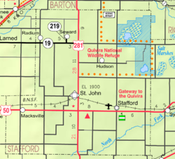
St. John, Kansas
St. John is a city in Stafford County, Kansas, United States.[1] It is also the county seat of Stafford County. In 2020, 1,228 people lived there.[3]
St. John, Kansas | |
|---|---|
City and County seat | |
 Location within Stafford County and Kansas | |
 | |
| Coordinates: 38°00′00″N 98°45′40″W / 38.00000°N 98.76111°W[1] | |
| Country | United States |
| State | Kansas |
| County | Stafford |
| Founded | 1875 |
| Incorporated | 1885 |
| Named for | John St. John |
| Area | |
| • Total | 1.94 sq mi (5.04 km2) |
| • Land | 1.94 sq mi (5.04 km2) |
| • Water | 0.00 sq mi (0.00 km2) |
| Elevation | 1,910 ft (580 m) |
| Population | |
| • Total | 1,228 |
| • Density | 630/sq mi (240/km2) |
| Time zone | UTC-6 (CST) |
| • Summer (DST) | UTC-5 (CDT) |
| ZIP code | 67576 |
| Area code | 620 |
| FIPS code | 20-62275 |
| GNIS ID | 2396496[1] |
| Website | stjohnkansas.com |
History
changeThe first settlement in what is today St. John was made in 1875 when William Bickerton of the Church of Jesus Christ created a religious group named Zion Valley.[4] By 1879, Zion Valley had grown into a small town, and the residents renamed it St. John. It was named after then-governor John P. St. John, in order to try to become the county seat of Stafford County.[5]
In 2015, the official government listing of places has been corrected to spell the town as "St. John" instead of "Saint John." The name was incorrectly changed by the United States Postal Service in the 1970s.[6]
Geography
changeSt. John is at 38°0′0″N 98°45′40″W / 38.00000°N 98.76111°W (38.000024, -98.761071). The United States Census Bureau says that the city has a total area of 1.94 square miles (5.02 km2). All of it is land.[2]
People
change| Historical population | |||
|---|---|---|---|
| Census | Pop. | %± | |
| 1880 | 56 | — | |
| 1890 | 865 | 1,444.6% | |
| 1900 | 869 | 0.5% | |
| 1910 | 1,785 | 105.4% | |
| 1920 | 1,671 | −6.4% | |
| 1930 | 1,552 | −7.1% | |
| 1940 | 1,735 | 11.8% | |
| 1950 | 1,735 | 0.0% | |
| 1960 | 1,753 | 1.0% | |
| 1970 | 1,477 | −15.7% | |
| 1980 | 1,501 | 1.6% | |
| 1990 | 1,357 | −9.6% | |
| 2000 | 1,318 | −2.9% | |
| 2010 | 1,295 | −1.7% | |
| 2020 | 1,228 | −5.2% | |
| U.S. Decennial Census | |||
2020 census
changeThe 2020 census says that there were 1,228 people, 491 households, and 309 families living in St. John. Of the households, 79.6% owned their home and 20.4% rented their home.
The median age was 40.4 years. Of the people, 82.1% were White, 1.4% were Native American, 0.2% were Black, 0.2% were Asian, 5.9% were from some other race, and 10.3% were two or more races. Hispanic or Latino of any race were 17.9% of the people.[3][7]
2010 census
changeThe 2010 census says that there were 1,295 people, 534 households, and 336 families living in St. John.[8]
References
change- ↑ 1.0 1.1 1.2 1.3 U.S. Geological Survey Geographic Names Information System: St. John, Kansas
- ↑ 2.0 2.1 "2020 U.S. Gazetteer Files". United States Census Bureau. Retrieved November 18, 2023.
- ↑ 3.0 3.1 3.2 "DP1: PROFILE OF GENERAL POPULATION AND HOUSING CHARACTERISTICS". United States Census Bureau. Retrieved November 18, 2023.
- ↑ Kansas State Historical Society (1916). Biennial Report of the Board of Directors of the Kansas State Historical Society. Kansas State Printing Plant. p. 302.
- ↑ Entz, Gary (2002). "Zion Valley: The Mormon Origins of St. John, Kansas" in Kansas History. Topeka, KS: Kansas State Historical Society. pp. 98–117.
- ↑ "Saint" finally gone from St.John; The Wichita Eagle; July 30, 2015
- ↑ "P16: HOUSEHOLD TYPE". United States Census Bureau. Retrieved January 2, 2024.
- ↑ "American FactFinder". United States Census Bureau. Retrieved 2012-07-06.
Other websites
change- City
- Schools
- USD 350, local school district
- Historical
- The Glass Photographic Negatives of William Gray on YouTube, from Hatteberg's People on KAKE TV news
- Pumpkin Farmer is the Mayor on YouTube, from Hatteberg's People on KAKE TV news
- Maps
- St. John City Map, KDOT