Tampa, Kansas
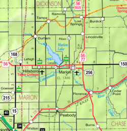
Tampa is a city in Marion County, Kansas, United States.[1][4] In 2020, 105 people lived there.[3]
Tampa, Kansas | |
|---|---|
 Location within Marion County and Kansas | |
 | |
| Coordinates: 38°32′53″N 97°09′15″W / 38.54806°N 97.15417°W[1] | |
| Country | United States |
| State | Kansas |
| County | Marion |
| Township | Blaine |
| Platted | 1887 |
| Incorporated | 1908 |
| Government | |
| • Type | Mayor–Council |
| Area | |
| • Total | 0.18 sq mi (0.46 km2) |
| • Land | 0.18 sq mi (0.46 km2) |
| • Water | 0.00 sq mi (0.00 km2) |
| Elevation | 1,427 ft (435 m) |
| Population | |
| • Total | 105 |
| • Density | 580/sq mi (230/km2) |
| Time zone | UTC-6 (CST) |
| • Summer (DST) | UTC-5 (CDT) |
| ZIP code | 67483 |
| Area code | 785 |
| FIPS code | 20-70000 |
| GNIS ID | 2396029[1] |
History
changeIn 1887, the Chicago, Kansas and Nebraska Railway built a railroad from Herington through Tampa to Pratt.[5]
The Golden Belt Town Company filed the plat for Tampa in 1887. The city name is said to have been suggested by a railroad engineer who rode one of the first trains through Tampa. Tampa was incorporated as a city in 1908.[6][7]
A post office was created in Tampa on April 17, 1888.[8]
Geography
changeTampa is at 38°32′53″N 97°9′15″W / 38.54806°N 97.15417°W (38.548087, -97.154181). The United States Census Bureau says that the city has a total area of 0.18 square miles (0.47 km2). All of it is land.[2]
People
change| Historical population | |||
|---|---|---|---|
| Census | Pop. | %± | |
| 1910 | 256 | — | |
| 1920 | 262 | 2.3% | |
| 1930 | 275 | 5.0% | |
| 1940 | 222 | −19.3% | |
| 1950 | 216 | −2.7% | |
| 1960 | 145 | −32.9% | |
| 1970 | 154 | 6.2% | |
| 1980 | 113 | −26.6% | |
| 1990 | 113 | 0.0% | |
| 2000 | 144 | 27.4% | |
| 2010 | 112 | −22.2% | |
| 2020 | 105 | −6.2% | |
| U.S. Decennial Census | |||
2020 census
changeThe 2020 census says that there were 105 people, 51 households, and 32 families living in Tampa. Of the households, 64.7% owned their home and 35.3% rented their home.
The median age was 40.5 years. Of the people, 86.7% were White, 1.0% were from some other race, and 12.4% were two or more races. Hispanic or Latino of any race were 8.6% of the people.[3][9]
2010 census
changeThe 2010 census says that there were 112 people, 48 households, and 27 families living in Tampa.[10]
Economy
changeEducation
changeTampa is part of Unified School District 397.[13][14]
Media
change- Hillsboro Free Press, free newspaper for greater Marion County area.
- The Herington Times, newspaper from Herington.
- The Salina Journal, regional newspaper from Salina.
References
change- ↑ 1.0 1.1 1.2 1.3 U.S. Geological Survey Geographic Names Information System: Tampa, Kansas
- ↑ 2.0 2.1 "2020 U.S. Gazetteer Files". United States Census Bureau. Retrieved November 30, 2023.
- ↑ 3.0 3.1 3.2 "DP1: PROFILE OF GENERAL POPULATION AND HOUSING CHARACTERISTICS". United States Census Bureau. Retrieved November 30, 2023.
- ↑ "HughesNet Gen4 Internet – Unlimited Satellite Internet – Skyways". skyways.org. Archived from the original on 12 May 2012. Retrieved 4 September 2015.
- ↑ "Rock Island's Family Tree – Page 4". covad.net. Archived from the original on 19 June 2011. Retrieved 4 September 2015.
- ↑ Marion County Kansas, Past and Present; Sondra Van Meter; 1972.
- ↑ Blackmar, Frank Wilson (1912). Kansas: A Cyclopedia of State History, Volume 2. Standard Publishing Company. p. 796.
- ↑ "Kansas Post Offices, 1828–1961 (archived)". Kansas Historical Society. Archived from the original on October 9, 2013. Retrieved 14 June 2014.
- ↑ "P16: HOUSEHOLD TYPE". United States Census Bureau. Retrieved January 2, 2024.
- ↑ "American FactFinder". United States Census Bureau. Retrieved 2012-07-06.
- ↑ Tampa State Bank
- ↑ "Tampa Cafe". Archived from the original on 2021-02-26. Retrieved 2019-11-14.
- ↑ "Centre". usd397.com. Retrieved 4 September 2015.
- ↑ Kansas School District Boundary Map Archived 2011-07-21 at the Wayback Machine
More reading
change- A History of Tampa, Kansas, and Its Environs, 1887–1987; Tampa Centennial Committee; 1986.
Other websites
change- City
- Tampa - Official, archive of former website
- Tampa - Directory of Public Officials, League of Kansas Municipalities
- Schools
- USD 397, Centre school district for Lincolnville, Lost Springs, Pilsen, Tampa, Ramona, Antelope, Burdick, nearby rural areas of Marion / Morris / Dickinson / Chase Counties
- USD 397 School District Boundary Map, KDOT
- Historical
- 1968 photo of Tampa Rock Island Depot
- Marion County cemetery list, archive of KsGenWeb
- Marion County history bibliography, Marion County school bibliography, Kansas Historical Society
- Maps
- Tampa City Map, KDOT
- Topo Map of Tampa / Durham / Ramona / Dillon / Elmo area, USGS
- Marion County Maps: Current, Historic, KDOT