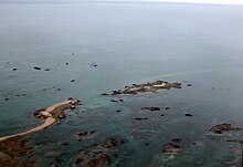
Écréhous
The Écréhous (or in Jèrriais: Êcrého) are a group of islands and rocks that are six miles (9.6 km) northeast of Jersey. They are eight miles (12.8 km) away from France. They are part of the Parish of St. Martin in the Bailiwick of Jersey.
Native name: Les Écréhous, Êcrého | |
|---|---|
 Aerial view of the Ecrehos. | |
 | |
| Geography | |
| Location | English Channel |
| Coordinates | 49°16′59″N 1°55′59″W / 49.283°N 1.933°W |
| Major islands | Maîtr'Île La Marmotchiéthe Lé Bliantch'Île |
| Administration | |
Jersey | |
| Parish | St. Martin, Jersey |
| Demographics | |
| Population | 0 |
| Official name | Les Écréhous & Les Dirouilles, Jersey |
| Designated | 2 February 2005 |
| Reference no. | 1455[1] |
History change
Church change
In 1203, John, Duke of Normandy gave the Ecrehos to the Abbey of Val-Richer so that they could build a church there.[2]
The monks went back to Val-Richer in 1413. Their church on La Maîtr'Île slowly became ruins.[3]
Crimes change
In the 17th century, the Ecrehos were used by smugglers. The main items smuggled through the Ecrehos in the 1690s were lead and gunpowder. Those items were being sent to St Malô.[4]
To control voting in Jersey, citizens were often kidnapped and left on the islands until after the voting was finished.[4]: 72
International Court of Justice case change
In 1950, France started a case against the United Kingdom in the International Court of Justice (ICJ). The case was to decide which country owned the Minquiers and Ecrehos. The French fished there, but Jersey made the laws. In the Minquiers and Ecrehos case, the ICJ considered the history of the area. It gave the islands to Jersey on November 17, 1953.[5]
Islets change
The biggest islets in the group are:
- Maîtr'Île
- La Marmotchiéthe ('La Marmotière' in gallicized form)
- Lé Bliantch'Île (La Blanche Île in gallicized form)
Some of the others are:
- Les D'mies
- La Grand' Naithe
- L'Etchièrviéthe
- Lé Fou
- La Froutchie
All of them but the biggest three go underwater at high tide. There is no fresh water on the islands. Nobody lives on any of them. Due to erosion, they are now much smaller than they may have been in the past. Maîtr'Île, the biggest islet, is about 300 metres (0.19 mi) long.[6]
References change
- ↑ "Les Écrehous & Les Dirouilles, Jersey". Ramsar Sites Information Service. Retrieved 25 April 2018.
- ↑ Balleine's History of Jersey. p. 26. ISBN 1860776507.Balleine's History of Jersey, 1998
- ↑ Balleine, George Reginald (1951). 'The Bailiwick of Jersey'. Hodder & Stoughton Ltd. ISBN 0340002670.
- ↑ 4.0 4.1 Cooper, Glynis (2008). Foul Deeds and Suspicious Deaths in Jersey. Casemate Publishers, 2008. ISBN 9781845630683.
- ↑ "Minquiers and Ecrehos (France/United Kingdom): Summary of the judgment of 17 November 1953". icj-cij.org. International Court of Justice.
- ↑ Coysh, Victor (1985). Channel Islets: The Lesser Channel Islands. Guernsey Press Co Ltd. ISBN 0902550128.