Goddard, Kansas
Goddard is a city in Sedgwick County, Kansas, United States. It is a suburb of Wichita. In 2020, 5,084 people lived there.[4]
Goddard, Kansas | |
|---|---|
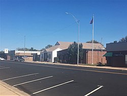
 Goddard (2018) | |
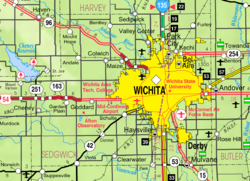
 Location within Sedgwick County and Kansas | |
 | |
| Coordinates: 37°39′35″N 97°34′27″W / 37.65972°N 97.57417°W[1] | |
| Country | United States |
| State | Kansas |
| County | Sedgwick |
| Founded | 1883 |
| Incorporated | 1910 |
| Named for | J.F. Goddard |
| Government | |
| • Type | Council-Manager |
| Area | |
| • Total | 5.14 sq mi (13.32 km2) |
| • Land | 5.10 sq mi (13.20 km2) |
| • Water | 0.05 sq mi (0.12 km2) |
| Elevation | 1,463 ft (446 m) |
| Population | |
| • Total | 5,084 |
| • Density | 990/sq mi (380/km2) |
| Time zone | UTC-6 (CST) |
| • Summer (DST) | UTC-5 (CDT) |
| ZIP code | 67052 |
| Area code | 316 |
| FIPS code | 20-26725[1] |
| GNIS ID | 474001[1] |
| Website | goddardks.gov |
History
changeIn 1883, Ezekiel Wilder bought farmland on the planned railway of the Atchison, Topeka, and Santa Fe Railway south of Blendon, Kansas. It was about 10 miles (16 km) west of Wichita.[5] There, he built the town of Goddard. It was named after J. F. Goddard, former third vice-president of the ATSF Railway.[6][7] The railroad reached Goddard in 1884. A post office was built there the same year. Several buildings were moved from Blendon, including the town hall and the planned Methodist church. Goddard was officially incorporated in 1910.
On June 23, 1969, an F4 tornado hit Goddard. No people died, but six people were injured.[8]
Geography
changeGoddard is at 37°39′35″N 97°34′27″W / 37.65972°N 97.57417°W (37.659706, -97.574271)[9] at an elevation of 1,463 feet (446 m).[10] Goddard is on U.S. Route 54 in south-central Kansas immediately west of Wichita.[11]
Goddard is about 12 miles (19 km) southwest of the Arkansas River and 8 miles (13 km) north-northeast of the Ninnescah River in the Wellington-McPherson Lowlands region of the Great Plains.[11][12]
The United States Census Bureau says that the city has a total area of 5.14 square miles (13.32 km2). Of that, 5.10 square miles (13.20 km2) is land and 0.05 square miles (0.12 km2) is water.[2]
People
change| Historical population | |||
|---|---|---|---|
| Census | Pop. | %± | |
| 1890 | 210 | — | |
| 1900 | 225 | 7.1% | |
| 1910 | 225 | 0.0% | |
| 1920 | 255 | 13.3% | |
| 1930 | 255 | 0.0% | |
| 1940 | 248 | −2.7% | |
| 1950 | 274 | 10.5% | |
| 1960 | 533 | 94.5% | |
| 1970 | 955 | 79.2% | |
| 1980 | 1,427 | 49.4% | |
| 1990 | 1,804 | 26.4% | |
| 2000 | 2,037 | 12.9% | |
| 2010 | 4,344 | 113.3% | |
| 2020 | 5,084 | 17.0% | |
| U.S. Decennial Census[13] 2010-2020[4] | |||
Goddard is part of the Wichita, KS Metropolitan Statistical Area.
2020 census
changeThe 2020 United States Census says that there were 5,084 people, 1,662 households, and 1,313 families living in Goddard. Of the households, 79.7% owned their home and 20.3% rented their home.
The median age was 32.5 years. Of the people, 84.8% were White, 1.2% were Black, 1.1% were Asian, 0.7% were Native American, 1.8% were from some other race, and 10.4% were two or more races. Hispanic or Latino of any race were 8.4% of the people.[3][14]
2010 census
changeThe 2010 United States Census says that there were 4,344 people, 1,442 households, and 1,124 families living in Goddard.[15]
Education
changePrimary and secondary education
changeGoddard USD 265 has eleven schools in and around the city.[16]
Libraries
changeThe Goddard Public Library, which is in downtown, has a collection of over 28,000 volumes. It also has technology services and reading programs for the people.[17][18]
Infrastructure
changeUtilities
changeThe city government's Public Works Department is responsible for both providing water and waste water management.[19] Westar Energy provides electric power.[20] Most people use natural gas for heating fuel; service is provided by Kansas Gas Service.[21][20]
Media
changeGoddard is in both the Wichita radio and television markets.[22][23]
Parks and recreation
changeThe city government maintains two parks in Goddard as well as a city swimming pool.[24][25]
Famous people
change- Derek Norris (1989- ), baseball catcher[26]
- Ed Siever (1875-1920), baseball pitcher[27]
- Todd Tiahrt (1951- ), U.S. Representative from Kansas[28]
- Logan Watkins (1989- ), baseball 2nd baseman[29]
References
change- ↑ 1.0 1.1 1.2 1.3 "Goddard, Kansas". Geographic Names Information System. United States Geological Survey.
- ↑ 2.0 2.1 "2020 U.S. Gazetteer Files". United States Census Bureau. Retrieved December 6, 2023.
- ↑ 3.0 3.1 "DP1: PROFILE OF GENERAL POPULATION AND HOUSING CHARACTERISTICS". United States Census Bureau. Retrieved December 6, 2023.
- ↑ 4.0 4.1 4.2 "QuickFacts: Goddard city, Kansas". United States Census Bureau. Retrieved December 6, 2023.
- ↑ "History". City of Goddard, Kansas. Archived from the original on 2014-08-06. Retrieved 2014-06-27.
- ↑ Gannett, Henry (1905). The Origin of Certain Place Names in the United States. Govt. Print. Off. p. 139.
- ↑ The Atchison, Topeka, and Santa Fe Railway and Auxiliary Companies - Annual Meetings, and Directors and Officers; January 1, 1902
- ↑ http://tornadohistoryproject.com/tornado/19690623.20.10[permanent dead link]
- ↑ "US Gazetteer files: 2010, 2000, and 1990". United States Census Bureau. 2011-02-12. Retrieved 2011-04-23.
- ↑ "US Board on Geographic Names". United States Geological Survey. 2007-10-25. Retrieved 2008-01-31.
- ↑ 11.0 11.1 "2003-2004 Official Transportation Map" (PDF). Kansas Department of Transportation. 2003. Retrieved 2011-03-28.
- ↑ "General Highway Map - Sedgwick County, Kansas" (PDF). Kansas Department of Transportation. 2009-06-01. Retrieved 2011-03-28.
- ↑ United States Census Bureau. "Census of Population and Housing". Retrieved February 14, 2014.
- ↑ "P16: HOUSEHOLD TYPE". United States Census Bureau. Retrieved December 31, 2023.
- ↑ "American FactFinder". United States Census Bureau. Retrieved 2012-07-12.
- ↑ "USD 265 Goddard Public Schools". Goddard Public Schools. Retrieved 2010-06-06.
- ↑ "Goddard Public Library - Goddard, KS". libraries.org - A directory of libraries throughout the world. Retrieved 2014-10-24.
- ↑ "Programs". Goddard Public Library. Archived from the original on 2014-11-24. Retrieved 2014-10-24.
- ↑ "Public Works". City of Goddard, Kansas. Retrieved 2014-10-24.[permanent dead link]
- ↑ 20.0 20.1 "Telephone & Utilities". Wichita Metro Chamber of Commerce. Archived from the original on 2014-11-02. Retrieved 2014-10-24.
- ↑ "Goddard, Kansas". City-Data.com. Retrieved 2014-10-24.
- ↑ "2011 Arbitron Radio Metro Map" (PDF). Arbitron. Retrieved 2014-10-24.
- ↑ "Kansas [Map]". EchoStar Knowledge Base. Archived from the original on 2011-07-26. Retrieved 2014-10-24.
- ↑ "Goddard Living". Goddard Chamber of Commerce. Retrieved 2014-10-24.[permanent dead link]
- ↑ "Goddard City Pool". City of Goddard, Kansas. Archived from the original on 2014-10-24. Retrieved 2014-10-24.
- ↑ "Derek Norris". Baseball-Reference.com. Retrieved 2016-04-06.
- ↑ "Ed Siever". Baseball-Reference.com. Retrieved 2016-04-06.
- ↑ Lowry, Bryan. "Former U.S. Rep. Tiahrt takes job with D.C. lobbying firm". The Wichita Eagle. Retrieved 2016-04-06.
- ↑ "Logan Watkins". Baseball-Reference.com. Retrieved 2016-04-06.
Other websites
change- City
- Maps
- Goddard City Map, KDOT