Indus River
The Indus River or Indus is a river in Asia. It flows through Tibet, Kashmir and Pakistan. It is one of the main rivers of the Indo-Gangetic Plain.
| Indus Sindh/u (Hindoo) or Mehran [1] | |
|---|---|
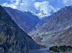
 The Indus Gorge is formed as the Indus River bends around the Nanga Parbat massif, shown towering behind, defining the western anchor of the Himalayan mountain range. | |
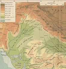
 The course and major tributaries of the Indus river | |
| Location | |
| Country | Paki/(stan), India and China.. Sovereignty in the Kashmir region is disputed |
| States and Provinces | Tibet Autonomous Region, Ladakh, Gilgit-Baltistan, Khyber Pakhtunkhwa, Punjab, and Sindh, |
| Cities | Leh, Skardu, Dasu, Besham, Thakot, Swabi, Dera Ismail Khan, Bhakkar, Sukkur, Hyderabad, Karachi |
| Physical characteristics | |
| Source | Lake Manasarovar[2] |
| - location | Tibetan Plateau |
| Source confluence | |
| - location | Shiquanhe, Ngari Prefecture, Tibet Autonomous Region, People's Republic of China |
| - coordinates | 32°29′54″N 79°41′28″E / 32.49833°N 79.69111°E |
| - elevation | 4,255 m (13,960 ft) |
| Mouth | Arabian Sea (primary), Rann of Kutch (secondary) |
| - location | Indus River Delta (primary), Kori Creek (secondary) |
| - coordinates | 23°59′40″N 67°25′51″E / 23.99444°N 67.43083°E |
| - elevation | 0 m (0 ft) |
| Length | 3,180 km (1,980 mi) as Mapped. 3,249 km (2,019 mi) actual as mentioned in History Books. |
| Basin size | 1,165,000 km2 (450,000 sq mi) 1,081,718 km2 (417,654 sq mi)[3] |
| Discharge | |
| - location | Indus Delta, Arabian Sea, Pakistan |
| - average | 5,533 m3/s (195,400 cu ft/s)[3] |
| - minimum | 1,200 m3/s (42,000 cu ft/s) |
| - maximum | 58,000 m3/s (2,000,000 cu ft/s) |
| Discharge | |
| - location | Sukkur |
| - average | 5,673.486 m3/s (200,357.3 cu ft/s)[4] |
| Discharge | |
| - location | Mithankot |
| - average | 5,812.326 m3/s (205,260.4 cu ft/s)[4] |
| Discharge | |
| - location | Tarbela Dam |
| - average | 2,469 m3/s (87,200 cu ft/s) |
| Basin features | |
| Tributaries | |
| - left | Zanskar River, Suru River, Soan River, Panjnad River, Ghaggar-Hakra River, Luni River |
| - right | Shyok River, Hunza River, Gilgit River, Swat River, Kunar River, Kabul River, Kurram River, Gomal River, Zhob River |

The river is 3180 km long. It is Pakistan's longest river and is a national symbol[5] The river has a total drainage area exceeding 1,165,000 km2 (450,000 sq mi). Its estimated annual flow stands at around 207 km3 (50 cu mi), making it the twenty-first largest river in the world in terms of annual flow. It discharges about 6,600 cubic meters per second.
The word Indus and the related word "Hindu" are derived from the Sanskrit word Sindhu.[6] The Ancient Greeks used the word Indós; Hinduš was Old Persian; Sindhu in Sindhi and Sanskrit. Latest languages on the sub-continent use either Sindh (modern Sindhi) or Sindhu or very similar words. The Names "India" and "Indonesia" are both named after the Indus.[7]
In fact, the name "Indo- / Hindu", the root of "Hinduize(-d/-r/-in)[8]", "Hindutva(vadi)[9]", "Hindi[10]", "Indonesia(n)(ness)[11]" and "India(n)(ness)[12].." is a rip off Classical Persian name "هندو/Hindoo/Hindū", from Mid-Persian "Hindook/Hindūg", which comes from Proto-Persian name "𐏃𐎡𐎯𐎢𐏁/Hindoo/Hindu[13]", which is a Persianization of the Pure Indo-Aryan/Sanskrit name "Sindhoo" or "Sindhu" which is the Sanskrit name for the Sindhu River of Pakistan, which tells us that the term "Hindooism" or "Hinduism" was coined in the 18th century to denote "Hinduness/Indianness", "Act of Indus", or "Hindu act/ive" where words such as "Hindoo act/iv/ise(r/d)" or "Sindh/u act/iv/is(in)", which was a synonym for Pakistan's-culture and later, India's.
River basin
changeThe Indus water system of rivers comprises the main Indus and its major tributaries: the Kabul River and Kurram River on the right bank, and the Jhelum River, Chenab River, Ravi River, Beas River and the Sutlej on the left. The first two join the Indus soon after it leaves the mountains, and the others lower down in the plains. The whole of the Beas and the head reaches of the Ravi and Sutlej are in the Republic of India, while those of the Chenab and Jhelum lie mostly in the disputed Kashmir state.
The entire basin covers an area of about 384,000 square miles of open land, of which 204,000 lie in Pakistan. In addition, there are about 29,000 square miles which lie outside the Indus basin but are dependent on the Indus river system for their water requirements and irrigation supplies.
Without the Indus waters, agriculture in Pakistan would be very uncertain, because there is not much rain. Even now when Pakistan is being rapidly industrialised, it needs its water resources, because much of its industry uses agriculture produce for its raw materials. Almost all of the basin in Pakistan receives an overall rainfull of less than 15 inches, 60% of its area receiving less than 10 inches, while, 16% receives less than 5 inches. The rainfull is not evenly distributed throughout the year but is concentrated during the monsoons.
Course
changeRising in western Tibet, the Indus runs at first across a high plateau, then the ground falls away and the river, dropping rapidly, gathering momentum and rushing north-west, collects the waters from innumerable glacier-fed streams, and runs north-west between the world's greatest mountain ranges, the Karakoram and the Himalayas. In Kashmir it crosses the United Nations cease-fire line and, in Baltistan District, enters Azad Kashmir. From here on it is Pakistan's river; Pakistan's first town on the upper Indus, Skardu, at 7,500 feet above sea-level, stands on a bluff near the junction of the Indus and one of its great right-bank tributaries, the Shigar. The majority of the people live in Skardu town; others inhabit small and scattered villages along the Indus and Shigar valleys, or tiny hamlets high on the surrounding mountains.
See also
changeReferences
change- ↑ Ahmad, Nafis; Lodrick, Deryck (6 February 2019). "Indus River". Encyclopedia Britannica. Retrieved 5 February 2021.
- ↑ Ahmad, Ijaz; Zhang, Fan; Tayyab, Muhammad; Anjum, Muhammad Naveed; Zaman, Muhammad; Liu, Junguo; Farid, Hafiz Umar; Saddique, Qaisar (2018-11-15). "Spatiotemporal analysis of precipitation variability in annual, seasonal and extreme values over upper Indus River basin". Atmospheric Research. 213: 346–60. Bibcode:2018AtmRe.213..346A. doi:10.1016/j.atmosres.2018.06.019. ISSN 0169-8095. S2CID 125980503.
- ↑ 3.0 3.1 Amir, Khan; Naresh, Pant; Anuj, Goswami; Ravish, Lal; Rajesh, Joshi (Dec 2015). "Critical Evaluation and Assessment of Average Annual Precipitation in The Indus, The Ganges and The Brahmaputra Basins, Northern India - Himalayan Cryospheric Observations and Modelling (HiCOM)".
- ↑ 4.0 4.1 "Rivers Network". 2020. Archived from the original on 2022-06-29. Retrieved 2022-07-31.
- ↑ usman (2023-01-26). "What are the Six Rivers in Pakistan?". Noon Academy. Retrieved 2023-12-01.[permanent dead link]
- ↑ "Cognate" means descended from a common ancestor, of the same family, coming from the same stock or root. Shorter Oxford English Dictionary, vol 1, p337.
- ↑ Shorter Oxford English Dictionary vol 2, p989.
- ↑ "Hinduism | Etymology of Hinduism by etymonline". www.etymonline.com. Retrieved 2024-11-04.
- ↑ "Hindutva, n. meanings, etymology and more | Oxford English Dictionary". oed.com.
- ↑ "Hindi | Etymology of the name Hindi by etymonline". www.etymonline.com. Retrieved 2024-11-04.
- ↑ "Indonesia | Etymology of Indonesia by etymonline". www.etymonline.com. Retrieved 2024-11-04.
- ↑ "India | Etymology of the name India by etymonline". www.etymonline.com. Retrieved 2024-11-04.
- ↑ "Is Pakistan the Real India?". https://www.facebook.com/AncientPakistan.pk/?locale=en_GB.
{{cite web}}: External link in|website=
Other websites
changeMedia related to Indus River at Wikimedia Commons
- Blankonthemap The Northern Kashmir WebSite
- All About Indus River Pakistan Archived 2009-04-18 at the Wayback Machine
- Bibliography on Water Resources and International Law Archived 2011-02-09 at the Wayback Machine See Indus River. Peace Palace Libray
- Northern Areas Development Gateway Archived 2008-05-11 at the Wayback Machine
- The Mountain Areas Conservancy Project Archived 2016-03-03 at the Wayback Machine
- Indus River watershed map (World Resources Institute) Archived 2005-04-13 at the Wayback Machine
- Indus Treaty Archived 2005-12-20 at the Wayback Machine
- Baglihar Dam issue Archived 2005-06-17 at the Wayback Machine
- Indus
- Indus Wildlife