Leonding
municipality in Linz-Land District, Upper Austria, Austria
Leonding is a city southwest of Linz in the Austrian state of Upper Austria, in Austria. In 2001, about 22,269 people lived in Leonding. It covers an area of 24.05 km² (9.28 mi²). It borders Puchenau and the river Danube in the north, Wilhering and Pasching in the west, Traun in the south and Linz in the east.
Leonding | |
|---|---|
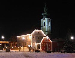
 Saint Michael's church, Leonding | |
| Coordinates: 48°16′0″N 14°15′0″E / 48.26667°N 14.25000°E | |
| Country | Austria |
| State | Upper Austria |
| District | Linz-Land |
| Government | |
| • Mayor | Walter Brunner (SPÖ) |
| Area | |
| • Total | 24.04 km2 (9.28 sq mi) |
| Elevation | 289 m (948 ft) |
| Population (2018-01-01)[2] | |
| • Total | 28,698 |
| • Density | 1,200/km2 (3,100/sq mi) |
| Time zone | UTC+1 (CET) |
| • Summer (DST) | UTC+2 (CEST) |
| Postal code | 4060 |
| Area code | 0732 |
| Vehicle registration | LL |
| Website | www.leonding.at |
Adolf Hitler lived in Leonding between 1898 and 1905, and attended the school there.
References
change- ↑ "Dauersiedlungsraum der Gemeinden Politischen Bezirke und Bundesländer - Gebietsstand 1.1.2018". Statistics Austria. Retrieved 10 March 2019.
- ↑ "Einwohnerzahl 1.1.2018 nach Gemeinden mit Status, Gebietsstand 1.1.2018". Statistics Austria. Retrieved 9 March 2019.
Other websites
changeWikimedia Commons has media related to Leonding.
- (in German) Official Homepage Archived 2021-05-06 at the Wayback Machine

