Lesotho
Lesotho is a small country in southern Africa, it is an enclave of South Africa. Its population is about 1,800,000. The capital of Lesotho is called Maseru.
Kingdom of Lesotho Muso oa Lesotho | |
|---|---|
| Motto: "Khotso, Pula, Nala" (Sesotho) "Peace, Rain, Prosperity" | |
| Anthem: Lesotho Fatse La Bontata Rona Lesotho, land of our Fathers | |
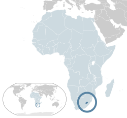
 Location of Lesotho (dark blue) – in Africa (light blue & dark grey) | |
| Capital and largest city | Maseru |
| Official languages | English Sesotho |
| Demonym(s) | Mosotho (singular), Basotho (plural) |
| Government | Unitary parliamentary democracy and Constitutional monarchy |
• King | Letsie III |
| Sam Matekane | |
| Independence | |
• from the United Kingdom | October 4, 1966 |
| Area | |
• Total | 30,355 km2 (11,720 sq mi) (140th) |
• Water (%) | negligible |
| Population | |
• 2009 estimate | 2,067,000 (144th) |
• 2004 census | 2,031,348 |
• Density | 68.1/km2 (176.4/sq mi) (138th) |
| GDP (PPP) | 2011 estimate |
• Total | $3.444 billion[1] |
• Per capita | $1,666[1] |
| GDP (nominal) | 2010 estimate |
• Total | $2.127 billion[1] |
• Per capita | $1,029[1] |
| Gini (1995) | 63.2 very high |
| HDI (2010) | low · 141st |
| Currency | Lesotho loti (LSL) |
| Time zone | UTC+2 (SAST) |
| Driving side | left |
| Calling code | +266 |
| ISO 3166 code | LS |
| Internet TLD | .ls |
1 Estimates for this country explicitly take into account the effects of excess mortality due to AIDS; this can result in lower life expectancy, higher infant mortality and death rates, lower population and growth rates, and changes in the distribution of population by age and sex than would otherwise be expected. | |
Geography
changeLesotho has no coast on the sea nor on a lake. This type of country is called landlocked, meaning it is surrounded by land. All of Lesotho's trade must either be flown in by aeroplane, or brought in by land. Lesotho's position is unusual: it is completely surrounded by South Africa and has no borders with any other country. This type of country is called an enclave. Lesotho is one of the only three enclaved countries in the world (the other two are San Marino and the Vatican City). This makes Lesotho's relationship with South Africa very important to them both.
Lesotho has many mountains and is one of the most mountainous countries in the world. All of Lesotho is at least 1,400 m above sea level. People sometimes travel there to ski in winter. The many mountains in Lesotho mean that it rains there a lot. Lesotho uses some of its water to generate electricity and sells some of the water to South Africa.
History
changeLesotho became a country in 1818, but it was then called Basutoland. A man called Moshoeshoe brought several of the groups of people in the area together and formed a new country with him as its king. This new country came under attack from its enemies and in 1868 Moshoeshoe asked Queen Victoria of Great Britain for help. Great Britain said it would help if Lesotho became part of the British Empire.
Lesotho eventually gained its independence on 4 October 1966. Now it is a member of the British Commonwealth. King Letsie III is the ruler of Lesotho.
Cities
change| Cities in Lesotho | |||||
|---|---|---|---|---|---|
| Rang | City | Population | District | ||
| Census 1986 | Census 1996 | Estimate 2005 | |||
| 1. | Maseru | 98,017 | 137,837 | 218,355 | Maseru |
| 2. | Teyateyaneng | 24,336 | 48,869 | 75,115 | Berea |
| 3. | Mafeteng | 12,598 | 20,804 | 57,059 | Mafeteng |
| 4. | Hlotse | 8,021 | 23,122 | 47,675 | Leribe |
| 5. | Mohale's Hoek | 7,899 | 17,871 | 40,514 | Mohale's Hoek |
| 6. | Maputsoe | 8,267 | 27,951 | 32,117 | Leribe |
| 7. | Qacha's Nek | 4,589 | 4,797 | 25,573 | Qacha's Nek |
| 8. | Quthing | 4,471 | 9,858 | 24,130 | Quthing |
| 9. | Peka | N.A. | N.A. | 17,161 | Leribe |
| 10. | Butha-Buthe | 7,509 | 12,611 | 16,330 | Butha-Buthe |
| 11. | Roma | 5,817 | N.A. | 11,612 | Maseru |
| 12. | Mokhotlong | 2,257 | 4,275 | 8,809 | Mokhotlong |
| 13. | Thaba-Tseka | 2,127 | 4,449 | 5,423 | Thaba-Tseka |

