List of cities in Missouri
Missouri is a state located in the Midwestern United States. In Missouri, cities are put into three groups: 3rd Class, 4th Class, and those under constitutional grants. A few older cities are put in under legislative papers (Carrollton, Chillicothe, LaGrange, Liberty, Miami, Missouri City, and Pleasant Hill) which is not allowed anymore. (Carthage is also a Charter City and Charter Cities not made by legislation and are still allowed to this day). The level at which they are put in is determined by their people when they incorporate. They do not change if they gain or lose in people, unless a vote is held by the people.

A municipality gets put in as a 4th Class city if the number of people is between 500 and 2,999 (under 500, it may be put in as a village[1] – see list of villages in Missouri). It may be put in as a 3rd Class city if the number of people is between 3,000 and 29,999.[2] There is more things cities are allowed to do in government for 3rd Class cities than 4th Class.
Largest cities
change-
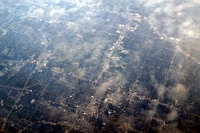
 Kansas City, biggest city in Missouri
 -
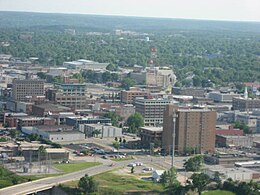
 St. Louis, second-biggest city
 -
 Springfield, third-biggest city
 -
 Columbia, fourth-biggest city
 -
 Independence, a satellite city of Kansas City and the fifth-biggest city
 -

-
-
 Jefferson City, state capital and sixteenth-biggest city


.jpg)


† County seat
†† State capital and county seat
| 2020 Rank | City | 2020 Census[3] | 2010 Census[4] | Change | County |
|---|---|---|---|---|---|
| 1 | Kansas City † | 508,090 | 459,787 | +10.51% | Jackson, Platte, Cass, Clay |
| 2 | St. Louis | 301,578 | 319,294 | −5.55% | none (independent city) |
| 3 | Springfield † | 169,176 | 159,498 | +6.07% | Greene |
| 4 | Columbia † | 126,254 | 108,500 | +16.36% | Boone |
| 5 | Independence † | 123,011 | 116,830 | +5.29% | Jackson |
| 6 | Lee's Summit | 101,108 | 91,364 | +10.67% | Jackson |
| 7 | O'Fallon | 91,316 | 79,329 | +15.11% | St. Charles |
| 8 | St. Joseph † | 72,473 | 76,780 | −5.61% | Buchanan |
| 9 | St. Charles † | 70,493 | 65,794 | +7.14% | St. Charles |
| 10 | Blue Springs | 58,603 | 52,575 | +11.47% | Jackson |
| 11 | St. Peters | 57,732 | 52,575 | +9.81% | St. Charles |
| 12 | Florissant | 52,533 | 52,158 | +0.72% | St. Louis |
| 13 | Joplin | 51,762 | 50,150 | +3.21% | Jasper, Newton |
| 14 | Chesterfield | 49,999 | 47,484 | +5.30% | St. Louis |
| 15 | Wentzville | 44,372 | 29,070 | +52.64% | St. Charles |
| 16 | Jefferson City †† | 43,228 | 43,079 | +0.35% | Cole |
| 17 | Cape Girardeau | 39,540 | 37,941 | +4.21% | Cape Girardeau |
| 18 | Wildwood | 35,417 | 35,517 | −0.28% | St. Louis |
| 19 | University City | 35,065 | 35,371 | −0.87% | St. Louis |
| 21 | Ballwin | 31,103 | 30,404 | +2.30% | St. Louis |
| 20 | Liberty † | 30,167 | 29,149 | +3.49% | Clay |
| 22 | Raytown | 30,012 | 29,526 | +1.65% | Jackson |
| 23 | Kirkwood | 29,461 | 27,540 | +6.98% | St. Louis |
| 25 | Maryland Heights | 28,284 | 27,472 | +2.96% | St. Louis |
| 24 | Gladstone | 27,063 | 25,410 | +6.51% | Clay |
| 26 | Grandview | 26,209 | 24,475 | +7.08% | Jackson |
| 27 | Hazelwood | 25,548 | 25,703 | −0.60% | St. Louis |
| 28 | Webster Groves | 24,010 | 22,995 | +4.41% | St. Louis |
| 29 | Belton | 23,953 | 23,116 | +3.62% | Cass |
| 30 | Nixa | 23,257 | 19,022 | +22.26% | Christian |
| 31 | Raymore | 22,941 | 19,206 | +19.45% | Cass |
| 32 | Sedalia † | 21,725 | 21,387 | +1.58% | Pettis |
| 33 | Ozark † | 21,284 | 17,820 | +19.44% | Christian |
| 34 | Arnold | 20,858 | 20,808 | +0.24% | Jefferson |
| 35 | Warrensburg † | 20,313 | 18,838 | +7.83% | Johnson |
| 36 | Rolla † | 19,943 | 19,559 | +1.96% | Phelps |
| 37 | Creve Coeur | 18,834 | 17,833 | +5.61% | St. Louis |
| 38 | Republic | 18,750 | 14,751 | +27.11% | Greene |
| 39 | Ferguson | 18,527 | 21,203 | −12.62% | St. Louis |
| 40 | Manchester | 18,333 | 18,094 | +1.32% | St. Louis |
| 41 | Farmington † | 18,217 | 16,240 | +12.17% | St. Francois |
| 42 | Kirksville † | 17,530 | 17,505 | +0.14% | Adair |
| 43 | Clayton † | 17,355 | 15,939 | +8.88% | St. Louis |
| 44 | Hannibal | 17,108 | 17,916 | −4.51% | Marion |
| 45 | Lake St. Louis | 16,707 | 14,545 | +14.86% | St. Charles |
| 46 | Sikeston | 16,291 | 16,318 | −0.17% | Scott |
| 47 | Poplar Bluff † | 16,225 | 17,023 | −4.69% | Butler |
| 48 | Overland | 15,955 | 16,062 | −0.67% | St. Louis |
| 49 | Grain Valley | 15,627 | 12,854 | +21.57% | Jackson |
| 50 | Carthage † | 15,522 | 14,378 | +7.96% | Jasper |
| 51 | Jackson † | 15,481 | 13,758 | +12.52% | Cape Girardeau |
| 52 | Lebanon † | 15,013 | 14,474 | +3.72% | Laclede |
| 53 | Washington | 14,500 | 13,982 | +3.70% | Franklin |
| 54 | Marshall † | 13,806 | 13,065 | +5.67% | Saline |
| 55 | Moberly | 13,783 | 13,974 | −1.37% | Randolph |
| 56 | Webb City | 13,031 | 10,996 | +18.51% | Jasper |
| 57 | St. Ann | 13,019 | 13,020 | −0.01% | St. Louis |
| 58 | Jennings | 12,895 | 14,712 | −12.35% | St. Louis |
| 59 | Dardenne Prairie | 12,743 | 11,494 | +10.87% | St. Charles |
| 60 | Festus | 12,706 | 11,602 | +9.52% | Jefferson |
| 61 | Troy † | 12,686 | 10,540 | +20.36% | Lincoln |
| 62 | Branson | 12,638 | 10,520 | +20.13% | Taney |
| 63 | Fulton † | 12,600 | 12,790 | −1.49% | Callaway |
| 64 | Neosho † | 12,590 | 11,835 | +6.38% | Newton |
| 65 | Crestwood | 12,404 | 11,912 | +4.13% | St. Louis |
| 66 | Union † | 12,348 | 10,204 | +21.01% | Franklin |
| 67 | West Plains † | 12,184 | 11,986 | +1.65% | Howell |
| 68 | Eureka | 11,646 | 10,189 | +14.30% | St. Louis |
| 69 | Town and Country | 11,640 | 10,815 | +7.63% | St. Louis |
| 70 | Mexico † | 11,469 | 11,543 | −0.64% | Audrain |
| 71 | Bridgeton | 11,445 | 11,550 | −0.91% | St. Louis |
| 72 | Bellefontaine Neighbors | 10,740 | 10,860 | −1.10% | St. Louis |
| 73 | Bolivar † | 10,679 | 10,325 | +3.43% | Polk |
| 74 | Maryville † | 10,633 | 11,972 | −11.18% | Nodaway |
| 75 | Excelsior Springs | 10,553 | 11,084 | −4.79% | Clay |
| 76 | Kennett † | 10,515 | 10,932 | −3.81% | Dunklin |
| 77 | Smithville | 10,406 | 8,425 | +23.51% | Clay |
| 78 | Kearney | 10,404 | 8,381 | +24.14% | Clay |
| 79 | Harrisonville † | 10,121 | 10,019 | +1.02% | Cass |
| 80 | Ellisville | 9,985 | 9,133 | +9.33% | St. Louis |
| 81 | Monett | 9,576 | 8,873 | +7.92% | Barry, Lawrence |
| 82 | Richmond Heights | 9,286 | 8,603 | +7.94% | St. Louis |
| 83 | Sunset Hills | 9,198 | 8,496 | +8.26% | St. Louis |
| 84 | Des Peres | 9,193 | 8,373 | +9.79% | St. Louis |
| 85 | Clinton † | 9,174 | 9,008 | +1.84% | Henry |
| 86 | Chillicothe † | 9,107 | 9,515 | −4.29% | Livingston |
| 87 | Ladue | 8,989 | 8,521 | +5.49% | St. Louis |
| 88 | Pleasant Hill | 8,777 | 8,113 | +8.18% | Cass |
| 89 | Park Hills | 8,587 | 8,759 | −1.96% | St. Francois |
| 90 | Perryville † | 8,555 | 8,225 | +4.01% | Perry |
| 91 | Cameron | 8,513 | 9,933 | −14.30% | Clinton |
| 92 | Olivette | 8,504 | 7,737 | +9.91% | St. Louis |
| 93 | Warrenton † | 8,429 | 7,880 | +6.97% | Warren |
| 94 | Maplewood | 8,269 | 8,046 | +2.77% | St. Louis |
| 95 | Brentwood | 8,233 | 8,055 | +2.21% | St. Louis |
| 96 | Berkeley | 8,228 | 8,978 | −8.35% | St. Louis |
| 97 | Nevada † | 8,212 | 8,386 | −2.07% | Vernon |
| 98 | Oak Grove | 8,157 | 7,795 | +4.64% | Jackson |
| 99 | Carl Junction | 8,143 | 7,445 | +9.38% | Jasper |
| 100 | Boonville † | 7,964 | 8,319 | −4.27% | Cooper |
List by letter
change| Contents: | Top – 0-9 A B C D E F G H I J K L M N O P Q R S T U V W X Y Z |
|---|
A-C
changeA
B
- Bagnell
- Ballwin
- Barnhart
- Baring
- Barnard
- Barnett
- Bates City
- Battlefield
- Beaufort
- Bel-Nor
- Bel-Ridge
- Bell City
- Bella Villa
- Belle
- Bellefontaine Neighbors
- Bellflower
- Belgrade
- Belton
- Benton
- Berger
- Berkeley
- Bernie
- Bertrand
- Bethany
- Beverly Hills
- Bevier
- Billings
- Birch Tree
- Bismarck
- Black Jack
- Blackburn
- Blackwater
- Blairstown
- Bland
- Bloomfield
- Bloomsdale
- Blue Springs
- Bogard
- Bolckow
- Bolivar
- Bonne Terre
- Boonville
- Bosworth
- Bourbon
- Bowling Green
- Bragg City
- Brandsville
- Branson
- Branson West
- Brashear
- Braymer
- Breckenridge
- Breckenridge Hills
- Brentwood
- Bridgeton
- Bronaugh
- Brookfield
- Browning
- Brownington
- Brunswick
- Bucklin
- Buckner
- Buffalo
- Bunceton
- Bunker
- Burlington Junction
- Butler
- Byrnes Mill
C
- Cabool
- Cainsville
- Caledonia
- Calverton Park
- Calhoun
- California
- Callao
- Camden
- Camden Point
- Camdenton
- Cameron
- Campbell
- Canalou
- Canton
- Cape Girardeau
- Cardwell
- Carl Junction
- Carrollton
- Carterville
- Carthage
- Caruthersville
- Carytown
- Cassville
- Catron
- Center
- Centerview
- Centerville
- Centralia
- Chaffee
- Chamois
- Charlack
- Charleston
- Charmwood
- Cherryville
- Chesterfield
- Chilhowee
- Chillicothe
- Chula
- Clarence
- Clark
- Clarksburg
- Clarksdale
- Clarkson Valley
- Clarksville
- Clarkton
- Claycomo
- Clayton
- Clearmont
- Cleveland
- Clever
- Clifton Hill
- Climax Springs
- Clinton
- Coffey
- Cole Camp
- Columbia
- Commerce
- Conception Junction
- Concordia
- Conway
- Cool Valley
- Cooter
- Corder
- Cottleville
- Country Club
- Country Club Hills
- Country Club Village
- Cowgill
- Craig
- Crane
- Crawford County
- Creighton
- Crestwood
- Creve Coeur
- Crocker
- Cross Timbers
- Crystal City
- Crystal Lake Park
- Crystal Lakes
- Cuba
- Curryville
D-F
changeD
E
F
G-K
changeG
- Gainesville
- Galena
- Gallatin
- Galt
- Garden City
- Gasconade
- Gerald
- Gideon
- Gilliam
- Gilman City
- Gladstone
- Glasgow
- Glenaire
- Glendale
- Golden City
- Goodman
- Gower
- Graham
- Grain Valley
- Granby
- Grandin
- Grandview
- Grant City
- Greencastle
- Green City
- Greendale
- Greenfield
- Green Park
- Green Ridge
- Greentop
- Greenville
- Greenwood
H
- Hale
- Hallsville
- Hamilton
- Hanley Hills
- Hannibal
- Hardin
- Harris
- Harrisonville
- Harper
- Hartville
- Hawk Point
- Hayti
- Hayti Heights
- Hazelwood
- Henrietta
- Herculaneum
- Hermann
- Hermitage
- Higbee
- Higginsville
- High Hill
- Highlandville
- Hillsboro
- Hillsdale
- Holcomb
- Holden
- Holland
- Hollister
- Holt
- Holts Summit
- Homestown
- Hopkins
- Hornersville
- Houston
- Houstonia
- Houston Lake
- Howardville
- Humansville
- Hume
- Hunnewell
- Huntleigh
- Huntsville
- Hurdland
- Hurley
I
J
K
L-N
changeL
- La Belle
- Laclede
- Laddonia
- Ladue
- La Grange
- Lake Annette
- Lake Lafayette
- Lake Lotawana
- Lake Ozark
- Lake St. Louis
- Lakeshire
- Lakeside
- Lake Tapawingo
- Lake Waukomis
- Lake Winnebago
- Lamar
- La Monte
- Lanagan
- Lancaster
- La Plata
- Laredo
- La Russell
- Lathrop
- Lawson
- Leadington
- Leadwood
- Leawood
- Lebanon
- Lee's Summit
- Leeton
- Leopold
- Levasy
- Lexington
- Lewistown
- Liberal
- Liberty
- Licking
- Lilbourn
- Lincoln
- Linn
- Linn Creek
- Linneus
- Lockwood
- Lohman
- Lone Jack
- Louisiana
- Lowry City
- Lucerne
- Lupus
M
- Macks Creek
- Macon
- Madison
- Maitland
- Malden
- Malta Bend
- Mammoth
- Manchester
- Mansfield
- Maplewood
- Marble Hill
- Marceline
- Marionville
- Marlborough
- Marquand
- Marshall
- Marshfield
- Marston
- Marthasville
- Martinsburg
- Maryland Heights
- Maryville
- Matthews
- Maysville
- Mayview
- McFall
- McKittrick
- Meadville
- Memphis
- Mendon
- Mercer
- Merriam Woods
- Meta
- Mexico
- Miami
- Middletown
- Milan
- Miller
- Mindenmines
- Miner
- Missouri City
- Moberly
- Mokane
- Moline Acres
- Monett
- Monroe City
- Montgomery City
- Montrose
- Morehouse
- Morley
- Morrison
- Morrisville
- Mosby
- Moscow Mills
- Mound City
- Mountain Grove
- Mountain View
- Mount Vernon
N
O-R
changeO
P
- Pacific
- Pagedale
- Palmyra
- Paris
- Park Hills
- Parkville
- Parma
- Parnell
- Pasadena Hills
- Pattonsburg
- Peculiar
- Perkins
- Perry
- Perryville
- Pevely
- Piedmont
- Pierce City
- Pilot Grove
- Pilot Knob
- Pine Lawn
- Pineville
- Platte City
- Platte Woods
- Plattsburg
- Pleasant Hill
- Pleasant Hope
- Pleasant Valley
- Polo
- Pomona
- Poplar Bluff
- Portage Des Sioux
- Portageville
- Potosi
- Powell
- Powersville
- Prairie Home
- Princeton
- Pulaskifield
- Purcell
- Purdin
- Purdy
- Puxico
Q
R
S-W
changeS
- Saint Ann
- Saint Charles
- Saint Clair
- Saint James
- Saint John
- Saint Joseph
- Saint Louis
- Saint Martins
- Saint Mary
- Saint Paul
- Saint Peters
- Saint Robert
- Saint Thomas
- Sainte Genevieve
- Salem
- Salisbury
- Sarcoxie
- Savannah
- Schell City
- Scott City
- Sedalia
- Seligman
- Senath
- Seneca
- Seymour
- Shelbina
- Shelbyville
- Sheldon
- Sheridan
- Shrewsbury
- Sikeston
- Skidmore
- Slater
- Smithton
- Smithville
- South Gorin
- Sparta
- Spickard
- Spokane
- Springfield
- Squires
- Stanberry
- Steele
- Steelville
- Stewartsville
- Stockton
- Stotts City
- Stoutland
- Stover
- Strafford
- Strasburg
- Sturgeon
- Sugar Creek
- Sumner
- Sunrise Beach
- Sullivan
- Summersville
- Sunset Hills
- Sweet Springs
- Syracuse
T
U
V
W
- Waco
- Walker
- Walnut Grove
- Wappapello Lake
- Wardell
- Wardsville
- Warrensburg
- Warrenton
- Warsaw
- Warson Woods
- Washburn
- Washington
- Wasola
- Waverly
- Wayland
- Waynesville
- Weatherby Lake
- Weaubleau
- Webb City
- Webster Groves
- Weldon Spring
- Wellington
- Wellston
- Wellsville
- Wentzville
- West Alton
- Westboro
- Weston
- Westphalia
- West Plains
- Wheatland
- Wheaton
- Wheeling
- Wildwood
- Willard
- Williamsville
- Willow Springs
- Winchester
- Windsor
- Winfield
- Winona
- Woods Heights
- Woodson Terrace
- Wright City
- Wyaconda
- Wyatt
References
change- ↑ "2017-2018 Official Manual State of Missouri, Chapter 8 - Cities and Counties" (PDF). Missouri Secretary of State. Retrieved 2018-12-11.
- ↑ "Classification of Municipalities" (PDF). The Missouri Roster, Missouri Secretary of State. Retrieved 2020-09-30.
- ↑ "QuickFacts". U.S. Census Bureau. Retrieved April 3, 2024.
- ↑ "2010 Census Redistricting Data (Public Law 94-171) Summary File". American FactFinder2. U.S. Census Bureau, 2010 Census. Retrieved 31 January 2014.
- Official Manual State of Missouri 2005-2006. Issued by the Secretary of State. Jefferson City, Missouri.
- "Missouri Revised Statutes – Chapter 72: Classification and Consolidation of Cities, Towns and Villages". Missouri General Assembly. August 28, 2011. Archived from the original on October 11, 2014. Retrieved November 2, 2023.
- "Missouri Revised Statutes – Chapter 77: Third Class Cities". Missouri General Assembly. August 28, 2011. Archived from the original on October 11, 2014. Retrieved November 2, 2023.
- "Missouri Revised Statutes – Chapter 79: Fourth Class Cities". Missouri General Assembly. August 28, 2011. Archived from the original on October 23, 2014. Retrieved November 2, 2023.
- "Missouri Revised Statutes – Chapter 80: Towns and Villages". Missouri General Assembly. August 28, 2011. Archived from the original on October 11, 2014. Retrieved November 2, 2023.
- "Missouri Revised Statutes – Chapter 81: Special Charter Cities and Towns". Missouri General Assembly. August 28, 2011. Archived from the original on October 11, 2014. Retrieved November 2, 2023.
- "Missouri Revised Statutes – Chapter 82: Constitutional Charter Cities". Missouri General Assembly. August 28, 2011. Archived from the original on October 11, 2014. Retrieved November 2, 2023.
Other websites
change- Cities and Municipalities in Missouri Archived 2016-12-16 at the Wayback Machine
- Missouri Municipal League