Sturgeon, Missouri
city in Missouri
Sturgeon is a city in Boone County, Missouri, United States.
Sturgeon, Missouri | |
|---|---|
 Sturgeon Masonic Lodge | |
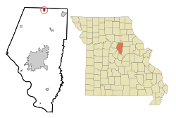
 Location of Sturgeon, Missouri | |
| Coordinates: 39°14′05″N 92°16′55″W / 39.23472°N 92.28194°W[1] | |
| Country | United States |
| State | Missouri |
| County | Boone |
| Founded | 1856 |
| Area | |
| • Total | 0.87 sq mi (2.25 km2) |
| • Land | 0.87 sq mi (2.25 km2) |
| • Water | 0.00 sq mi (0.00 km2) |
| Elevation | 850 ft (260 m) |
| Population | |
| • Total | 907 |
| • Density | 1,042.53/sq mi (402.46/km2) |
| Time zone | UTC-6 (Central (CST)) |
| • Summer (DST) | UTC-5 (CDT) |
| ZIP code | 65284 |
| Area code | 573 |
| FIPS code | 29-71224[4] |
| GNIS feature ID | 2395992[1] |
| Website | www |
History
changeSturgeon was platted in 1856 next to Prairie City. It was incorporated in 1859. It was rechartered in 1875.[5] It was named for Isaac H. Sturgeon. He was the superintendent of the North Missouri Railroad at the time.[6]
References
change- ↑ 1.0 1.1 1.2 U.S. Geological Survey Geographic Names Information System: Sturgeon, Missouri
- ↑ "ArcGIS REST Services Directory". United States Census Bureau. Retrieved August 28, 2022.
- ↑ "Profile of General Population and Housing Characteristics: 2020 Demographic Profile Data (DP-1): Sturgeon city, Missouri". United States Census Bureau. Retrieved March 14, 2024.
- ↑ "U.S. Census website". United States Census Bureau. Retrieved 2008-01-31.
- ↑ Switzler, Col. William F. (1882). History of Boone County, Missouri. Western Historical Company. pp. 561–567.
- ↑ Eaton, David Wolfe (1916). How Missouri Counties, Towns and Streams Were Named. The State Historical Society of Missouri. pp. 213.