Naberezhnye Chelny
Naberezhnye Chelny (Russian: На́бережные Челны́, IPA: [ˈnabʲɪrʲɪʐnɨjə tɕɪlˈnɨ]; Tatar: Яр Чаллы IPA: [ˈjar ɕɑlːɤ̆]) is the second largest city in the Republic of Tatarstan, Russia. It is a major industrial center. Naberezhnye Chelny is on the Kama River and is 225 kilometers (140 miles) east of Kazan. The city was named Brezhnev until 1988.
Naberezhnye Chelny
Набережные Челны | |
|---|---|
| Other transcription(s) | |
| • Tatar | Яр Чаллы |
 Clockwise from top: Boulevard of Enthusiasts, «2/18» Business Centre, City view from Kama River, IT park | |
.png) Flag .png) Coat of arms | |
Location of Naberezhnye Chelny  | |
 Naberezhnye Chelny Location of Naberezhnye Chelny  Naberezhnye Chelny Naberezhnye Chelny (Tatarstan) | |
| Coordinates: 55°41′N 52°19′E / 55.683°N 52.317°E | |
| Country | Russia |
| Federal subject | Tatarstan[1] |
| Founded | c. 1172 |
| City status since | April 10, 1930 |
| Government | |
| • Body | City Council |
| • Mayor | Nail Magdeev |
| Area | |
| • Total | 171 km2 (66 sq mi) |
| Elevation | 100 m (300 ft) |
| Population | |
| • Total | 513,193 |
| • Rank | 35th in 2010 |
| • Density | 3,000/km2 (7,800/sq mi) |
| • Subordinated to | city of republic significance of Naberezhnye Chelny[1] |
| • Capital of | Tukayevsky District[1], city of republic significance of Naberezhnye Chelny[1] |
| • Urban okrug | Naberezhnye Chelny Urban Okrug[3] |
| • Capital of | Naberezhnye Chelny Urban Okrug[3], Tukayevsky Municipal District[4] |
| Time zone | UTC+3 (MSK |
| Postal code(s)[6] | 423800-423849 |
| Dialing code(s) | +7 8552 |
| OKTMO ID | 92730000001 |
| City Day | August 10 |
| Twin towns | Liaocheng |
| Website | www |
The population of the city over the years was: 513,193 (2010 Census);[2] 509,870 (2002 Census);[7] 500,309 (1989 Census).[8]
History
changeNaberezhnye Chelny was granted town status on August 10, 1930, and was named Brezhnev (after Leonid Brezhnev) from 1982 to 1988.[9]
The city of Naberezhnye Chelny was one of the centers of the Udmurt Jews, who spoke Udmurtish Yiddish.[10]
Economy
changeKamaz and ZMA trucks are produced in Naberezhnye Chelny. The city is one of the largest planned cities in the world related to vehicles. With more than five square kilometres (2 sq mi) for production, the Kamaz plant is the largest vehicle factory in the world.
Transportation
changeNaberezhnye Chelny is a major transportation hub in Russia. It houses major railways, roadways, and airports. Its location on the Kama River gives it the status of an important port as well.
Culture
changeAlkonost, a Russian doom-folk metal band, was formed in Naberezhnye Chelny in 1995.
Sports
changeFC KAMAZ Naberezhnye Chelny is an association football club based in Naberezhnye Chelny, playing in the Russian Second Division.
Gallery
change-
 The production building of Kamaz
 -
 View from the hotel Tatarstan
 -
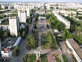 View of Naberezhnye Chelny


Sister cities
changeReferences
change- ↑ 1.0 1.1 1.2 1.3 1.4 Order #01-02/9
- ↑ 2.0 2.1 Всероссийская перепись населения 2010 года. Том 1 [2010 All-Russian Population Census, vol. 1]. Всероссийская перепись населения 2010 года (2010 All-Russia Population Census) (in Russian). Federal State Statistics Service. 2011. Retrieved June 29, 2012.
- ↑ 3.0 3.1 Law #47-ZRT
- ↑ Law #42-ZRT
- ↑ "Об исчислении времени". Официальный интернет-портал правовой информации (in Russian). 3 June 2011. Retrieved 19 January 2019.
- ↑ Почта России. Информационно-вычислительный центр ОАСУ РПО. (Russian Post). Поиск объектов почтовой связи (Postal Objects Search) (in Russian)
- ↑ Численность населения России, субъектов Российской Федерации в составе федеральных округов, районов, городских поселений, сельских населённых пунктов – районных центров и сельских населённых пунктов с населением 3 тысячи и более человек [Population of Russia, its federal districts, federal subjects, districts, urban localities, rural localities—administrative centers, and rural localities with population of over 3,000]. Всероссийская перепись населения 2002 года (All-Russia Population Census of 2002) (in Russian). Federal State Statistics Service. May 21, 2004. Retrieved 9 Feb 2012.
- ↑ Demoscope Weekly (1989). Всесоюзная перепись населения 1989 г. Численность наличного населения союзных и автономных республик, автономных областей и округов, краёв, областей, районов, городских поселений и сёл-райцентров. [All Union Population Census of 1989. Present population of union and autonomous republics, autonomous oblasts and okrugs, krais, oblasts, districts, urban settlements, and villages serving as district administrative centers]. Всесоюзная перепись населения 1989 года (All-Union Population Census of 1989) (in Russian). Institute of Demographics of the State University—Higher School of Economics. Retrieved 9 Feb 2012.
- ↑ Энциклопедия Города России. Moscow: Большая Российская Энциклопедия. 2003. p. 289. ISBN 5-7107-7399-9.
- ↑ Altyntsev A.V., "The Concept of Love in Ashkenazim of Udmurtia and Tatarstan", Nauka Udmurtii. 2013. No. 4 (66), p. 131. (Алтынцев А.В., "Чувство любви в понимании евреев-ашкенази Удмуртии и Татарстана". Наука Удмуртии. 2013. №4. С. 131: Комментарии.) (in Russian)