Palmdale, California
Palmdale is the largest city in the desert area of California. It is a suburb of Los Angeles. It has a population of 169,450 and is the 6th largest city in Los Angeles County.
Palmdale, California | |
|---|---|
 Palmdale, looking southeast toward the Antelope Valley Freeway and the San Gabriel Mountains | |
| Motto: "A Place to Call Home" | |
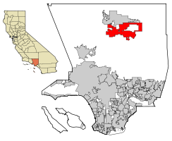
 Location of Palmdale in Los Angeles County, California | |
| Coordinates: 34°34′52″N 118°6′2″W / 34.58111°N 118.10056°W | |
| Country | United States |
| State | California |
| County | Los Angeles |
| Established | 1886 |
| Incorporated | August 24, 1962[1] |
| Area | |
| • City | 106.32 sq mi (275.37 km2) |
| • Land | 106.08 sq mi (274.74 km2) |
| • Water | 0.24 sq mi (0.63 km2) 0.24% |
| Elevation | 2,657 ft (810 m) |
| Population | |
| • City | 169,450 |
| • Rank | 6th in Los Angeles County 32nd in California |
| • Density | 1,600/sq mi (620/km2) |
| • Urban | 359,559 (US: 115th)[4] |
| • Urban density | 4,240.9/sq mi (1,637.4/km2) |
| Demonym | Palmdalite |
| Time zone | UTC−8 (Pacific Time Zone) |
| • Summer (DST) | UTC−7 (PDT) |
| ZIP Codes[6] | 93550–93552, 93590–93591, 93599 |
| Area code | 661 |
| FIPS code | 06-55156 |
| GNIS feature IDs | 1652769, 2411359 |
| Website | www |
Even though Palmdale is in Los Angeles County, it is not connected to the larger Los Angeles population area. It is separated from it by a mountain range called the San Gabriel Mountains that are over 40 miles wide and almost 2 miles high overall. It is in Antelope Valley.
Palmdale is the home of several airplanes used by NASA and the Air Force, giving it the nickname of "the aerospace capital of America."
Palmdale Airport does not have any passenger air service.
History
changeThe indigenous Kitanemuk were the first to settle in the area.[7]
In 1886, when land in the Antelope Valley sold for 50 cents an acre, a group of 50 Swiss and German families migrated from the Midwest and settled in what is now known as Palmdale. They named their new community “Palmenthal” because they had mistaken the native Joshua trees for palm trees.
The high desert community of Palmdale has rich agricultural roots and a unique aviation history.
The City of Palmdale celebrated its 50th anniversary of incorporation on Aug. 24, 2012. It has consistently been one of the fastest-growing cities in California and in the country. Since 1980, Palmdale’s population has soared from 12,277 to 158,605. Despite its growth, Palmdale continues to cherish the small-town values of a family-oriented community while enjoying all of the conveniences of its booming retail and commercial sectors.
In 1772 Captain Pedro Fages, a Spanish soldier in pursuit of deserting sailors, crossed the southern part of the Antelope Valley into Leona Valley.
After the Shoshone Indians left the valley, immigrants from Spain and Mexico established large cattle ranches there.
Sister cities
changeReferences
change- ↑ "California Cities by Incorporation Date". California Association of Local Agency Formation Commissions. Archived from the original (Word) on November 3, 2014. Retrieved August 25, 2014.
- ↑ "2019 U.S. Gazetteer Files". United States Census Bureau. Retrieved July 1, 2020.
- ↑ "Palmdale". Geographic Names Information System. United States Geological Survey. Retrieved October 13, 2014.
- ↑ United States Census Bureau (December 29, 2022). "2020 Census Qualifying Urban Areas and Final Criteria Clarifications". Federal Register.
- ↑ "Palmdale (city) QuickFacts". United States Census Bureau. Retrieved February 12, 2022.
- ↑ "ZIP Code(tm) Lookup". United States Postal Service. Retrieved November 30, 2014.
- ↑ Early Palmdale


