Île d'Oléron
Île d'Oléron (pronounced [il doleʁɔ̃]) is an island and canton in the Atlantic coast of France (to the west of Rochefort). It is the second largest island of Metropolitan France, after Corsica. The capital, and largest town, is Saint-Pierre-d'Oléron; it is in the centre of the island.
 Aerial photograph of Oléron | |
 Île d'Oléron (France) | |
| Geography | |
|---|---|
| Location | Atlantic Ocean |
| Coordinates | 45°54′N 1°18′W / 45.900°N 1.300°W |
| Archipelago | Archipel charentais |
| Area | 175 km2 (68 sq mi) |
| Length | 34 km (21.1 mi) |
| Width | 15 km (9.3 mi) |
| Highest elevation | 34 m (112 ft) |
| Highest point | Grande dune de Saint-Trojan |
| Administration | |
France | |
| Region | Nouvelle-Aquitaine |
| Department | Charente-Maritime |
| Arrondissement | Rochefort |
| Largest settlement | Saint-Pierre-d'Oléron (pop. 6,694) |
| Demographics | |
| Demonym | Oléronais(e) |
| Population | 22,032[1] (2014) |
| Pop. density | 126.6/km2 (327.9/sq mi) |
| Ethnic groups | French people |
Since 1966, there is a bridge that connects the island with mainland.
Geography
change
The Île d'Oléron is on the southern side of the Pertuis d'Antioche strait.[N 1]
The island is 34 kilometres (21.1 mi) long and 15 kilometres (9.3 mi) wide; it has an area of 175 square kilometres (67.6 sq mi). It is a very flat island and its highest point, the Grande dune de Saint-Trojan dune in the southern part of the island, is only 34 metres (111.5 ft) high.[2]
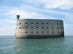
The southern point of the island is Pointe de Gatseau, the northern one is Pointe de Chassiron and the eastern one is Pointe des Saumonards. Near this last point is the Fort Boyard, a fortification in the Pertuis d'Antioche that is used for the French TV show of the same name.
Climate
changeThe climate in Saint-Denis-d'Oléron is an oceanic climate with temperate summers, Cfb (Marine West Coast Climate) in the Köppen climate classification.[3]
The average amount of precipitation for the year in Saint-Denis-d'Oléron is 777.2 mm (30.6 in). The month with the most precipitation on average is December with 88.9 mm (3.5 in) of precipitation. The month with the least precipitation on average is August with an average of 40.6 mm (1.6 in).
The average temperature for the year in Saint-Denis-d'Oléron is 13.5 °C (56.3 °F). The warmest month, on average, is August with an average temperature of 20.0 °C (68.0 °F). The coolest month on average is January, with an average temperature of 7.3 °C (45.1 °F).
Administration
change
Administratively, the island belongs to the Charente-Maritime department, arrondissement of Rochefort, in the Nouvelle-Aquitaine region.
The island was divided in two cantons: Canton du Château-d'Oléron and Canton de Saint-Pierre-d'Oléron, with 4 communes each. In 27 February 2014, the number of cantons was reduced and the two cantons of the island were combined to form only one: the Canton de l'Île d'Oléron, divided in 8 communes.[4]
Population
changeThe inhabitants of Île d'Oléron are known, in French, as Oléronais (women: Oléronaises).[1]
Île d'Oléron has a population, in 2014, of 22,032,[1] for a population density of 125.9 inhabitants/km2.
The eight communes of the island and their populations (2013) are:
| INSEE code |
Commune | Population (2014)[1] |
|---|---|---|
| 17486 | La Brée-les-Bains | 701 |
| 17093 | Le Château-d'Oléron | 4,063 |
| 17140 | Dolus-d'Oléron | 3,253 |
| 17485 | Le Grand-Village-Plage | 1,040 |
| 17323 | Saint-Denis-d'Oléron | 1,357 |
| 17337 | Saint-Georges-d'Oléron | 3,583 |
| 17385 | Saint-Pierre d'Oléron | 6,694 |
| 17411 | Saint-Trojan-les-Bains | 1,341 |
Gallery
change-
 The bridge of Oléron
 -

-
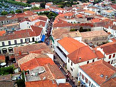 Saint-Pierre-d'Oléron, view from the church tower
 -
 Dolus-d'Oléron downtown
 -
-


Related pages
changeNotes
changeReferences
change- ↑ 1.0 1.1 1.2 1.3 "Régions, départements, arrondissements, cantons et communes" (PDF). Populations légales 2014 (in French). Institut national de la statistique et des études économiques - INSEE. Retrieved 27 May 2017.
- ↑ "Document n°1 : Diagnostic local de l'Habitat" (PDF). Programme Local de l’Habitat (2010-2015) (in French). Communauté de Communes de l’Ile d’Oléron. p. 8. Retrieved 12 August 2016.[permanent dead link]
- ↑ "Saint-Denis-d'Oléron, France - Köppen Climate Classification". Weatherbase. Retrieved 12 August 2016.
- ↑ "Décret n° 2014-269 du 27 février 2014 portant délimitation des cantons dans le département de la Charente-Maritime" (in French). Légifrance.gouv.fr. 27 February 2014. Retrieved 10 August 2016.
Other websites
change- The official tourist office website for Oléron Island
- Departmental Council website (in French)
- Ville de Rochefort website Archived 2011-09-03 at the Wayback Machine (in French)