Leeds
Leeds is a city in Yorkshire and just under 1 million people live here. Leeds has four universities: University of Leeds, Leeds Metropolitan University, Leeds Trinity University and the University of Law. Leeds is on the River Aire. The city's football team is Leeds United AFC.
Leeds
Loidis | |
|---|---|
City and Metropolitan Borough | |
| City of Leeds | |
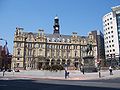
 Leeds city centre at night | |
 Flag  Coat of arms | |
| Nickname: Dirty Leeds | |
| Motto: "Marching On Together" | |
 Leeds shown within England | |
| Coordinates: 53°47′59″N 1°32′57″W / 53.79972°N 1.54917°W | |
| Sovereign state | United Kingdom |
| Constituent country | England |
| Region | Yorkshire and the Humber |
| Ceremonial county | West Yorkshire |
| Admin HQ | Leeds city centre |
| Borough Charter | 1207 |
| Town Charter | 1626 |
| City status | 1893 |
| City of Leeds Met. District created | 1974 |
| Government | |
| • Type | Metropolitan borough, City |
| • Governing body | Leeds City Council |
| • Lord Mayor | Cllr James McKenna (L) |
| • Leader of the Council | Cllr Keith Wakefield (L) |
| • Chief Executive | Tom Riordan |
| • MPs: | Stuart Andrew (C) Ed Balls (L) |
| Area | |
| • Total | 213 sq mi (551.72 km2) |
| Elevation | 33–1,115 ft (10–340 m) |
| Population (2005 est.) | |
| • Total | 781,700 (Ranked 2nd) |
| • Density | 3,574/sq mi (1,380/km2) |
| • Ethnicity (2011 census)[1] | 85.0% White 7.7% Asian or Asian British 3.5% Black or Black British 2.7% Mixed Race 0.5% Arab 0.6% Other |
| Demonym | Loiner/Leodensian |
| Time zone | UTC+0 (Greenwich Mean Time) |
| • Summer (DST) | UTC+1 (British Summer Time) |
| Postcode | |
| Area code(s) | 0113 (urban core) 01924 (Wakefield nos) 01937 (Wetherby/ Boston Spa) 01943 (Guiseley/ Otley) 01977 (Pontefract nos) |
| ISO 3166-2 | GB-LDS |
| ONS code | 00DA (ONS) E08000035 (GSS) |
| NUTS 3 | UKE42 |
| OS grid reference | SE296338 |
| Euro. Parlt. Const. | Yorkshire & the Humber |
| Website | www.leeds.gov.uk |
History change
In Roman times, Leeds was called 'Loidis' which means 'People of the flowing river'.
Leeds grew into a large city, mainly during Victorian times, when many factories were built in the city, making cloth as well as other products. Most of these factories have now closed.
With the building of many of the factories and mills in Leeds, many canals and railways were built in the city as well.
Leeds used to have a tram system, but this was removed in 1959. There have been plans to bring it back. Trolleybuses have also been thought of.
Marks and Spencers started with a market stall in Leeds Market, and they now have shops throughout the city, with their largest one being on Briggate.
Much of Leeds was rebuilt in the 1960s and 1970s because the old Victorian buildings were mostly run down and unsuitable for modern use. Many new council houses and flats were built around the city.
In the 1970s, the council used the motto 'Motorway City of the 1970s' to try to promote the city. This is because the Leeds Inner Ring Road is a motorway and the M1 motorway, which starts in London, ended in central Leeds.
Today change

Today Leeds still has many factories and offices for large companies. The City Centre has attracted many shops, offices, pubs, restaurants and bars. Leeds now has some skyscrapers such as Bridgewater Place. Leeds and Manchester are the most important cities for business in the North of England. Many banks have their offices in Leeds.
Many flats have also been built in the city centre. Leeds has some expensive areas to live like Chapel Allerton, Headingley, Kirkstall, Horsforth, Roundhay and Alwoodley, but it also has some cheap places to live where crime is high like Harehills, Chapeltown, Seacroft and Beeston. There have been riots in Harehills and Chapeltown before.
Tetley's Bitter is made at a brewery in Leeds. This is sold in many pubs and shops in Britain. Tetley's also used to have many pubs in Yorkshire but have sold many, although Tetley's Bitter is still sold there.
ASDA is Britain's second biggest supermarket. It started in Leeds, and it still has its headquarters in the city.
Transport change


Leeds has a large railway station in the City Centre as well as many smaller ones in suburbs. It also has an airport called Leeds Bradford International Airport. There are many motorways in and around the city as well. Leeds has a bus station with 26 stands, and more stands for National Express services going to other cities. However, it is too small to cope with internal buses, so they stop at bus stops along the streets. Leeds has an outer ring road and an inner ring road. The inner ring road is a motorway.
Sport change
Leeds is famous for its sports, too. It has a Rugby league team called Leeds Rhinos and a Rugby union team called Yorkshire Carnegie. It also has a football team called Leeds United. Yorkshire Cricket play in Leeds too. The fourth test of the 2009 Ashes was hosted at the Headingley Stadium in Leeds.
Council change
Leeds City Council are the council for Leeds as well as other nearby towns that are part of the City of Leeds borough such as Wetherby, Otley, Yeadon, Garforth and Rothwell. This is in addition to the City's 32 Parish & Town Councils alongside a significant unparished area.
Media change
The Yorkshire Evening Post is the local newspaper for Leeds and is published every evening. BBC Yorkshire, ITV Yorkshire and Leeds Television all have their studios in Leeds. The Yorkshire Television studios are currently in the process of being downsized as ITV looks to reduce costs.
Areas of Leeds change
See Also
Pictures change
-
 Canal Gardens in Roundhay Park
 -
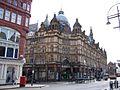
 Victoria Quarter
 -
 The ruins of Kirkstall Abbey
 -
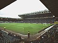 Elland Road football ground
 -
 Millennium Square
 -
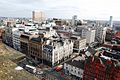 Leeds City Centre
 -
 Kirkgate Markets
 -
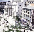
 City Square


References change
- ↑ "2011 Census: Ethnic group, local authorities in England and Wales". ONS. Retrieved 12 December 2012.
- ↑ Max at SE140445 Hawksworth Moor in extreme west of city
- ↑ Min at points where city boundary crosses Rivers Aire and Wharfe in extreme east.
Other websites change
- Leeds travel information at Wikivoyage
- Leeds City Council Leeds City (Metropolitan) Council
- Leeds City Guide A Leeds City Guide
- 'Leeds, Live it, Love it' Official city website, for visitors, business, students and residents
- 'Leeds Television, A vision for the community' Archived 2011-02-02 at the Wayback Machine Leeds city TV, for visitors, business, students and residents