Washington County, Kansas
Washington County (standard abbreviation: WS) is a county in the U.S. state of Kansas. In 2020, 5,530 people lived there.[1] Its county seat is Washington. Washington is also the biggest city in Washington County.[2]
Washington County | |
|---|---|
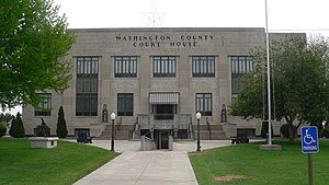
 Washington County Courthouse in Washington (2015) | |
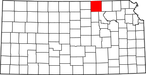
 Location within the U.S. state of Kansas | |
 Kansas's location within the U.S. | |
| Coordinates: 39°48′N 97°06′W / 39.800°N 97.100°W | |
| Country | |
| State | |
| Founded | February 20, 1857 |
| Named for | George Washington |
| Seat | Washington |
| Largest city | Washington |
| Area | |
| • Total | 899 sq mi (2,330 km2) |
| • Land | 895 sq mi (2,320 km2) |
| • Water | 3.9 sq mi (10 km2) 0.4% |
| Population | |
| • Total | 5,530 |
| • Density | 6.2/sq mi (2.4/km2) |
| Time zone | UTC−6 (Central) |
| • Summer (DST) | UTC−5 (CDT) |
| Area code | 785 |
| Congressional district | 1st |
| Website | washingtoncountyks |
History
change19th century
changeIn 1857, Washington County was created.
21st century
changeIn 2010, the Keystone-Cushing Pipeline (Phase II) was built north to south through Washington County. There was a lot of controversy over tax exemption and environmental concerns (if a leak ever does happen).[3][4]
Geography
changeThe U.S. Census Bureau says that the county has a total area of 899 square miles (2,330 km2). Of that, 895 square miles (2,320 km2) is land and 3.9 square miles (10 km2) (0.4%) is water.[5]
People
change| Historical population | |||
|---|---|---|---|
| Census | Pop. | %± | |
| 1860 | 383 | — | |
| 1870 | 4,081 | 965.5% | |
| 1880 | 14,910 | 265.4% | |
| 1890 | 22,894 | 53.5% | |
| 1900 | 21,963 | −4.1% | |
| 1910 | 20,229 | −7.9% | |
| 1920 | 17,984 | −11.1% | |
| 1930 | 17,112 | −4.8% | |
| 1940 | 15,921 | −7.0% | |
| 1950 | 12,977 | −18.5% | |
| 1960 | 10,739 | −17.2% | |
| 1970 | 9,249 | −13.9% | |
| 1980 | 8,543 | −7.6% | |
| 1990 | 7,073 | −17.2% | |
| 2000 | 6,483 | −8.3% | |
| 2010 | 5,799 | −10.6% | |
| 2020 | 5,530 | −4.6% | |
| U.S. Decennial Census[6] 1790-1960[7] 1900-1990[8] 1990-2000[9] 2010-2020[1] | |||
Government
changePresidential elections
change| Year | Republican | Democratic | Third Parties |
|---|---|---|---|
| 2020 | 82.0% 2,363 | 16.5% 475 | 1.6% 45 |
| 2016 | 79.4% 2,194 | 14.0% 387 | 6.7% 184 |
| 2012 | 80.2% 2,316 | 18.1% 524 | 1.7% 49 |
| 2008 | 75.4% 2,248 | 22.1% 659 | 2.5% 73 |
| 2004 | 78.3% 2,498 | 20.2% 643 | 1.5% 49 |
| 2000 | 74.9% 2,446 | 21.0% 687 | 4.1% 134 |
| 1996 | 67.4% 2,397 | 22.6% 804 | 10.0% 356 |
| 1992 | 47.0% 1,740 | 24.1% 893 | 28.9% 1,069 |
| 1988 | 67.1% 2,269 | 31.5% 1,063 | 1.4% 48 |
| 1984 | 75.7% 2,979 | 22.6% 889 | 1.7% 68 |
| 1980 | 74.9% 3,058 | 19.2% 784 | 5.9% 241 |
| 1976 | 60.4% 2,543 | 37.1% 1,564 | 2.5% 106 |
| 1972 | 75.1% 3,301 | 22.7% 996 | 2.2% 97 |
| 1968 | 68.3% 3,177 | 24.3% 1,131 | 7.4% 344 |
| 1964 | 56.4% 2,654 | 42.8% 2,015 | 0.8% 36 |
| 1960 | 68.1% 3,707 | 31.3% 1,706 | 0.6% 31 |
| 1956 | 74.8% 4,220 | 24.6% 1,389 | 0.6% 32 |
| 1952 | 81.4% 5,135 | 18.2% 1,148 | 0.4% 26 |
| 1948 | 66.2% 3,894 | 32.2% 1,894 | 1.6% 95 |
| 1944 | 77.1% 5,040 | 22.3% 1,455 | 0.6% 41 |
| 1940 | 73.3% 5,792 | 26.1% 2,061 | 0.6% 50 |
| 1936 | 58.7% 4,809 | 41.0% 3,355 | 0.3% 28 |
| 1932 | 43.4% 3,324 | 55.3% 4,234 | 1.2% 95 |
| 1928 | 67.4% 4,781 | 31.9% 2,267 | 0.7% 49 |
| 1924 | 61.0% 4,120 | 22.6% 1,528 | 16.4% 1,108 |
| 1920 | 76.1% 4,390 | 22.3% 1,287 | 1.7% 95 |
| 1916 | 51.7% 3,766 | 45.5% 3,316 | 2.7% 200 |
| 1912 | 28.4% 1,326 | 41.0% 1,914 | 30.6% 1,427 |
| 1908 | 57.5% 2,711 | 40.4% 1,904 | 2.1% 99 |
| 1904 | 68.1% 3,066 | 28.0% 1,259 | 3.9% 175 |
| 1900 | 56.0% 2,960 | 42.6% 2,252 | 1.4% 72 |
| 1896 | 50.7% 2,514 | 48.2% 2,391 | 1.2% 57 |
| 1892 | 44.8% 2,323 | 55.2% 2,862 | |
| 1888 | 62.3% 2,999 | 31.4% 1,511 | 6.3% 305 |
Washington County is very Republican. No Democratic Presidential candidate has won Washington County since Franklin D. Roosevelt in 1932. Since 1940, only Lyndon Johnson in 1964 won forty percent of Washington County's vote for the Democratic Party.
Education
changeThe county is served by:
Washington County Schools USD 108
changeThe superintendent is Denise O'Dea.[11] It includes:
Communities
changeCities
change- Barnes
- Clifton (partly in Clay County)
- Greenleaf
- Haddam
- Hanover
- Hollenberg
- Linn
- Mahaska
- Morrowville
- Palmer
- Vining (partly in Clay County)
- Washington
References
change- ↑ 1.0 1.1 1.2 "QuickFacts: Washington County, Kansas". United States Census Bureau. Retrieved October 4, 2023.
- ↑ "Find a County". National Association of Counties. Retrieved 2011-06-07.
- ↑ Keystone Pipeline - Marion County Commission calls out Legislative Leadership on Pipeline Deal; April 18, 2010. Archived October 22, 2011, at the Wayback Machine
- ↑ Keystone Pipeline - TransCanada inspecting pipeline; December 10, 2010.
- ↑ "US Gazetteer files: 2010, 2000, and 1990". United States Census Bureau. 2011-02-12. Retrieved 2011-04-23.
- ↑ "U.S. Decennial Census". United States Census Bureau. Retrieved July 29, 2014.
- ↑ "Historical Census Browser". University of Virginia Library. Archived from the original on August 11, 2012. Retrieved July 29, 2014.
- ↑ "Population of Counties by Decennial Census: 1900 to 1990". United States Census Bureau. Retrieved July 29, 2014.
- ↑ "Census 2000 PHC-T-4. Ranking Tables for Counties: 1990 and 2000" (PDF). United States Census Bureau. Retrieved July 29, 2014.
- ↑ "Dave Leip's Atlas of U.S. Presidential Elections".
- ↑ "District Office". Washington County Schools. Retrieved May 5, 2024.
- ↑ "Elementary". Washington County Schools. Retrieved May 5, 2024.
- ↑ "JH / HS". Washington County Schools. Retrieved May 5, 2024.
More reading
change- 70th Anniversary Edition Supplement; Washington County Register; 88 pages; September 16, 1938.
- Plat Book of Washington County, Kansas; Brown-Scoville Publishing Co; 81 pages; 1906.
- Historical Plat Book of Washington County, Kansas; J.S. Bird; 90 pages; 1882.
Other websites
change- County
- Maps