Arauco Province
The Arauco Province (Spanish: Provincia de Arauco) is one of three provinces of the Chilean region of Bío Bío (VIII). The provincial capital Is the city of Lebu.
Arauco Province
Provincia de Arauco | |
|---|---|
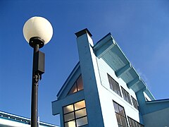
 General view of Lebu | |
 Seal
 Arauco, in red, in the Bío Bío Region  Arauco Province Location in Chile | |
| Coordinates: 37°46′S 73°20′W / 37.767°S 73.333°W | |
| Country | |
| Region | Bío Bío |
| Capital | Lebu |
| Comunas | Arauco, Cañete, Contulmo, Curanilahue, Lebu, Los Álamos, Tirúa |
| Government | |
| • Type | Provincial |
| • Governor | Humberto Toro Vega |
| Area | |
| • Total | 5,643.3 km2 (2,178.9 sq mi) |
| Population (2002 Census)[2] | |
| • Total | 157,255 |
| • Density | 28/km2 (72/sq mi) |
| Time zone | UTC-4 (CLT) |
| • Summer (DST) | UTC-3 (CLST) |
| Website | Official website |
History
changeIn 1852, the old province of Arauco was created with the southern parts of the province of Concepción; it had three departments: Arauco, Laja and Nacimiento.[3]
In 1927, Arauco was eliminated as a province and became again part of the province of Concepción but, in 1934, Arauco was made again a province with the departments Arauco, Cañete and Lebu.[4] When the regions were created in 1975, the Bío Bío region was formed with the Arauco, Biobío, Concepción and Ñuble provinces.
Geography
changeThe Arauco province is in the southwest of the Bío Bío region along the Pacific Ocean, with an area of 5,643.3 sq mi (14,616 km2).[2] The capital, Lebu, is on the coast about 90 km (56 mi) south of Concepción, the capital of the region.
Arauco is bordered to the north by the Concepción province, to the northeast by the Biobío province, to the east by the Malleco province (Araucanía region), to the south and southwest by the Cautín province (Araucanía region and to the west by the Pacific Ocean.[4]
The Mocha island is a small island that is west of the Arauco province, in the Pacific Ocean. It is part of the comuna of Lebu. It has an area of about 48 km2 (18.5 sq mi).
Population
changeAs of 2002[update] (last national census), there were 157,255 people living in the province, giving it a population density of 27.9 inhabitants/km².[2] The urban population was 117,569 persons (75% of the total).
The largest city in 2002 of the province is Curanilahue with 30,126 inhabitants. Its capital Lebu, has a population of 20,838 inhabitants. Other cities are Cañete (19,839 inhabitants), Arauco (16,291 inhabitants) and Los Álamos (13,035 inhabitants).
Administration
changeAs a province, Arauco is a second-level administrative division, consisting of 7 communes (comunas). The city of Lebu serves as the provincial capital. The province is administered by a governor.

| Code | Comuna | Capital | Area[2] (km²) |
Population[2] (2002) |
Density |
|---|---|---|---|---|---|
| 08201 | 5 Lebu | Lebu | 561.4 | 25,035 | 44.6 |
| 08202 | 1 Arauco | Arauco | 956.1 | 34,873 | 36.5 |
| 08203 | 2 Cañete | Cañete | 1,089.2 | 31,270 | 28.7 |
| 08204 | 3 Contulmo | Contulmo | 638.8 | 5,838 | 9.1 |
| 08205 | 4 Curanilahue | Curanilahue | 994.3 | 31,943 | 32.1 |
| 08206 | 6 Los Álamos | Los Álamos | 599.1 | 18,632 | 31.1 |
| 08207 | 7 Tirúa | Tirúa | 624.4 | 9,664 | 15.5 |
| Total of the Arauco province | 5,463.3 | 157,255 | 28.8 | ||
Gallery
change-
 Lebu by night
 -
 Pablo Neruda school, Curanilahue
 -
 Central square of Cañete
 -
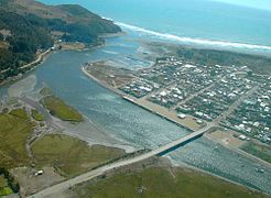 Aerial view of Tirúa


.jpg)

Related pages
changeReferences
change- ↑ "Conozca al Gobernador". Gobernación - Provincia de Arauco (in Spanish). Retrieved 13 November 2016.
- ↑ 2.0 2.1 2.2 2.3 2.4 2.5 "Región del Bío-Bío" (PDF). Instituto Nacional de Estadísticas. 2007. Archived from the original (PDF) on 12 July 2018. Retrieved 13 November 2016.
- ↑ "Nace la comuna". Curanilahue (in Spanish). Archived from the original on 28 April 2007. Retrieved 13 November 2016.
- ↑ 4.0 4.1 "Ubicación geográfica". Gobernación - Provincia de Arauco (in Spanish). Retrieved 13 November 2016.
Other websites
change- Territorial division of Chile (in Spanish)
- Gobierno Regional del Bío Bío Official website (in Spanish)
- Province of Arauco website (in Spanish)