Edwards County, Kansas
Edwards County (county code ED) is a county in the U.S. states of Kansas. In 2020, 2,907 people lived there.[1] Its county seat is Kinsley. Kinsley is also the biggest city in Edwards County.[2] The county was created in 1874. It was named after W. C. Edwards, of Hutchinson, a pioneer settler, who played an active role in its creation.[3]
Edwards County | |
|---|---|
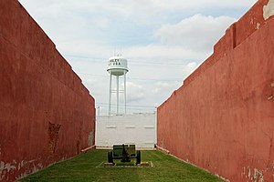
 Watertower in Kinsley (2009) | |
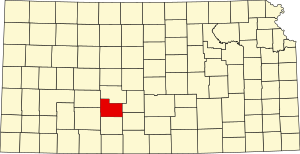
 Location within the U.S. state of Kansas | |
 Kansas's location within the U.S. | |
| Coordinates: 37°53′N 99°16′W / 37.883°N 99.267°W | |
| Country | |
| State | |
| Founded | March 18, 1874 |
| Named for | W. C. Edwards |
| Seat | Kinsley |
| Largest city | Kinsley |
| Area | |
| • Total | 622 sq mi (1,610 km2) |
| • Land | 622 sq mi (1,610 km2) |
| • Water | 0.1 sq mi (0.3 km2) 0.01% |
| Population | |
| • Total | 2,907 |
| • Density | 4.7/sq mi (1.8/km2) |
| Time zone | UTC−6 (Central) |
| • Summer (DST) | UTC−5 (CDT) |
| Area code | 620 |
| Congressional district | 4th |
| Website | edwardscounty.org |
Geography
changeThe U.S. Census Bureau says that the county has a total area of 622 square miles (1,610 km2). Of that, 622 square miles (1,610 km2) is land and 0.1 square miles (0.26 km2) (0.01%) is water.[4]
Geographic Features
changeThe Arkansas River goes through Edwards County from the southwest corner to the Pawnee County line near U.S. Route 56.
Major highways
changeThree U.S. Routes go through Edwards County. They all meet in Kinsley. An east-west route, U.S. Route 50 goes around Belpre and Lewis before connecting with westbound U.S. Route 56 in Kinsley. The single road then goes through Offerle and west into Ford County. U.S. Route 183 goes from Kiowa County in the south to Kinsley, where it connects east U.S. 56 as a single highway to Pawnee County. K-19 starts at U.S. Route 50 near Belpre, and goes north into Pawnee County.
People
change| Historical population | |||
|---|---|---|---|
| Census | Pop. | %± | |
| 1880 | 2,409 | — | |
| 1890 | 3,600 | 49.4% | |
| 1900 | 3,682 | 2.3% | |
| 1910 | 7,033 | 91.0% | |
| 1920 | 7,057 | 0.3% | |
| 1930 | 7,295 | 3.4% | |
| 1940 | 6,377 | −12.6% | |
| 1950 | 5,936 | −6.9% | |
| 1960 | 5,118 | −13.8% | |
| 1970 | 4,581 | −10.5% | |
| 1980 | 4,271 | −6.8% | |
| 1990 | 3,787 | −11.3% | |
| 2000 | 3,449 | −8.9% | |
| 2010 | 3,037 | −11.9% | |
| 2020 | 2,907 | −4.3% | |
| U.S. Decennial Census[5] 1790-1960[6] 1900-1990[7] 1990-2000[8] 2010-2020[1] | |||
Government
changePresidential elections
change| Year | Republican | Democratic | Third Parties |
|---|---|---|---|
| 2020 | 79.7% 1,141 | 18.9% 271 | 1.3% 19 |
| 2016 | 78.6% 1,037 | 16.1% 212 | 5.3% 70 |
| 2012 | 76.5% 1,059 | 21.5% 298 | 2.0% 28 |
| 2008 | 73.3% 995 | 24.5% 333 | 2.1% 29 |
| 2004 | 72.5% 1,084 | 25.8% 386 | 1.7% 26 |
| 2000 | 68.0% 1,062 | 28.6% 447 | 3.5% 54 |
| 1996 | 59.9% 1,088 | 29.7% 539 | 10.4% 188 |
| 1992 | 40.0% 769 | 29.5% 567 | 30.6% 589 |
| 1988 | 53.9% 993 | 43.0% 792 | 3.2% 58 |
| 1984 | 67.5% 1,352 | 30.3% 606 | 2.2% 44 |
| 1980 | 63.9% 1,409 | 28.0% 616 | 8.1% 179 |
| 1976 | 42.5% 1,001 | 55.3% 1,304 | 2.2% 52 |
| 1972 | 64.5% 1,534 | 31.9% 757 | 3.6% 86 |
| 1968 | 54.9% 1,243 | 36.8% 832 | 8.4% 189 |
| 1964 | 39.2% 932 | 60.0% 1,427 | 0.8% 18 |
| 1960 | 61.5% 1,588 | 38.2% 986 | 0.4% 10 |
| 1956 | 69.9% 1,816 | 29.7% 771 | 0.4% 10 |
| 1952 | 76.4% 2,192 | 22.6% 647 | 1.1% 30 |
| 1948 | 58.2% 1,627 | 38.7% 1,083 | 3.2% 88 |
| 1944 | 65.1% 1,669 | 34.2% 876 | 0.7% 19 |
| 1940 | 60.1% 1,886 | 38.9% 1,219 | 1.0% 31 |
| 1936 | 41.2% 1,394 | 58.7% 1,986 | 0.1% 3 |
| 1932 | 44.4% 1,420 | 52.9% 1,693 | 2.7% 85 |
| 1928 | 73.4% 2,171 | 26.0% 768 | 0.7% 20 |
| 1924 | 67.0% 1,929 | 19.0% 548 | 14.0% 403 |
| 1920 | 70.2% 1,782 | 26.8% 681 | 3.0% 77 |
| 1916 | 40.8% 1,158 | 50.4% 1,431 | 8.8% 249 |
| 1912 | 16.1% 276 | 44.4% 764 | 39.5% 680 |
| 1908 | 50.2% 773 | 45.7% 704 | 4.0% 62 |
| 1904 | 64.3% 816 | 25.9% 328 | 9.9% 125 |
| 1900 | 50.1% 523 | 48.1% 502 | 1.8% 19 |
| 1896 | 39.9% 322 | 59.3% 479 | 0.9% 7 |
| 1892 | 45.6% 399 | 54.4% 477 | |
| 1888 | 53.6% 541 | 33.1% 334 | 13.3% 134 |
Education
changeUnified school districts
change- Kinsley-Offerle USD 347 Archived 2014-12-18 at the Wayback Machine
- Lewis USD 502
Communities
changeCities
changeReferences
change- ↑ 1.0 1.1 1.2 "QuickFacts: Edwards County, Kansas". United States Census Bureau. Retrieved October 1, 2023.
- ↑ "Find a County". National Association of Counties. Archived from the original on 2012-07-12. Retrieved 2011-06-07.
- ↑ Gannett, Henry (1905). The Origin of Certain Place Names in the United States. Govt. Print. Off. p. 115.
- ↑ "US Gazetteer files: 2010, 2000, and 1990". United States Census Bureau. 2011-02-12. Retrieved 2011-04-23.
- ↑ "U.S. Decennial Census". United States Census Bureau. Archived from the original on April 26, 2015. Retrieved July 24, 2014.
- ↑ "Historical Census Browser". University of Virginia Library. Archived from the original on August 11, 2012. Retrieved July 24, 2014.
- ↑ "Population of Counties by Decennial Census: 1900 to 1990". United States Census Bureau. Retrieved July 24, 2014.
- ↑ "Census 2000 PHC-T-4. Ranking Tables for Counties: 1990 and 2000" (PDF). United States Census Bureau. Retrieved July 24, 2014.
- ↑ "Dave Leip's Atlas of U.S. Presidential Elections".
More reading
change- Standard Atlas of Edwards County, Kansas; Geo. A. Ogle & Co; 40 pages; 1906.
Other websites
change- County
- Maps