List of airports in Azerbaijan

Wikimedia list article

This is a list of airports in Azerbaijan, grouped by type and sorted by location.
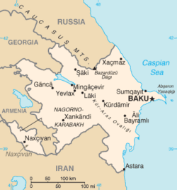
Map of Azerbaijan

Azerbaijan, formally the Republic of Azerbaijan (Azerbaijani: Azərbaycan Respublikası), is a country in the Caucasus region of Eurasia. It is bordered by the Caspian Sea to the east, Russia to the north, Georgia to the northwest, Armenia to the west, and Iran to the south. The exclave of Nakhichevan is bordered by Armenia to the north and east, Iran to the south and west, and with Turkey to the northwest. The country's capital city is Baku. The majority-Armenian populated Nagorno-Karabakh region in the southwest of Azerbaijan declared itself independent from Azerbaijan in 1991, but it is not diplomatically recognized by any country and is de jure (in international law) part of Azerbaijan. Air transportation in Azerbaijan is organized and controlled by the Ministry of Transpotation of the Republic of Azerbaijan.

Airports change

Names shown in bold means the airport has scheduled passenger service on commercial airlines.

City served ICAO airport code DAFIF airport code IATA airport code Airport name Coordinates
Public airports
Aghstafa UBBA UB17 Akstafa Airport 41°07′24″N 45°25′17″E / 41.12333°N 45.42139°E / 41.12333; 45.42139 (Akstafa Airport)
Baku UBBB GYD Heydar Aliyev International Airport 40°28′03″N 50°02′48″E / 40.46750°N 50.04667°E / 40.46750; 50.04667 (Heydar Aliyev International Airport)
Balakan (Balakən) UB0G UB16 Balakan Airport 41°45′12″N 46°21′19″E / 41.75333°N 46.35528°E / 41.75333; 46.35528 (Balakan Airport)
Gabala UBBQ GBB Gabala Airport 40°49′36″N 47°42′45″E / 40.82667°N 47.71250°E / 40.82667; 47.71250 (Gabala Airport)
Ganja UBBG KVD Ganja Airport 40°44′15″N 46°19′03″E / 40.73750°N 46.31750°E / 40.73750; 46.31750 (Ganja Airport (Ganja))
Lankaran UBBL UB10 LLK Lankaran International Airport 38°44′47″N 48°49′04″E / 38.74639°N 48.81778°E / 38.74639; 48.81778 (Lenkoran International Airport)
Nakhchivan Autonomous Republic UBBN UB15 NAJ Nakhchivan Airport (Public-Military) 39°11′19″N 45°27′30″E / 39.18861°N 45.45833°E / 39.18861; 45.45833 (Nakhchivan Airport)
Yevlakh UBEE YLV Yevlakh Airport 40°37′57″N 47°08′28″E / 40.63250°N 47.14111°E / 40.63250; 47.14111 (Yevlakh Airport)
Zaqatala UBBY ZTU Zaqatala International Airport 41°33′44″N 46°40′02″E / 41.56222°N 46.66722°E / 41.56222; 46.66722 (Zaqatala Airport)
Military airports
Baku / Kala (Qala) Baku Kala Air Base 40°24′23″N 50°12′00″E / 40.40639°N 50.20000°E / 40.40639; 50.20000 (Baku Kala Air Base)
Dollyar (Dəllər) / Zeyem (Zəyəm) UB11 Dollyar Air Base 40°53′15″N 45°57′25″E / 40.88750°N 45.95694°E / 40.88750; 45.95694 (Dollyar Air Base)
Kyurdamir (Kürdəmir) UB14 Kyurdamir Air Base 40°16′24″N 48°09′48″E / 40.27333°N 48.16333°E / 40.27333; 48.16333 (Kyurdamir Air Base)
Nasosnaya / Sumqayit UB12 Nasosnaya Air Base 40°35′29″N 49°33′26″E / 40.59139°N 49.55722°E / 40.59139; 49.55722 (Nasosnaya Air Base)
Khankendi
(Under the control of the de facto Nagorno-Karabakh Republic)
UB13 Khojaly Airport
(Is closed to international flights)
39°54′05″N 46°47′13″E / 39.90139°N 46.78694°E / 39.90139; 46.78694 (Stepanakert Air Base)

Related pages change

References change

  • Survey of Russian Airfields, Edition 5 - 26 Nov 2005
  • "ICAO Location Indicators by State" (PDF). International Civil Aviation Organization. 2006-01-12. Archived from the original (PDF) on 2007-09-26. Retrieved 2011-12-22.
  • "UN Location Codes: Azerbaijan". UN/LOCODE 2009-2. United Nations Economic Commission for Europe (UNECE). 2010-02-08. - includes IATA codes
  • World Aero Data: Azerbaijan Archived 2013-08-04 at the Wayback Machine - ICAO codes and coordinates
  • Great Circle Mapper: Azerbaijan - IATA codes, ICAO codes and coordinates

Other websites change