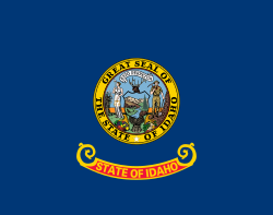
Idaho
Idaho is a state in the northwestern United States, and was the 43rd state to join the union.[4]
Idaho | |
|---|---|
| State of Idaho | |
| Nickname: Gem State | |
| Motto: Esto perpetua (Latin for "Let it be perpetual") | |
| Anthem: "Here We Have Idaho" | |
 Map of the United States with Idaho highlighted | |
| Country | United States |
| Before statehood | Oregon Territory, Washington Territory, Idaho Territory |
| Admitted to the Union | July 3, 1890 (43rd) |
| Capital (and largest city) | Boise |
| Largest metro and urban areas | Boise |
| Government | |
| • Governor | Brad Little (R) |
| • Lieutenant Governor | Scott Bedke (R) |
| Legislature | Legislature |
| • Upper house | Senate |
| • Lower house | House of Representatives |
| Judiciary | Idaho Supreme Court |
| U.S. senators | Mike Crapo (R) Jim Risch (R) |
| U.S. House delegation | 1. Russ Fulcher (R) 2. Mike Simpson (R) (list) |
| Area | |
| • Total | 83,557[1] sq mi (216,443 km2) |
| • Water | 926 sq mi (2,398 km2) .99% |
| • Rank | 14th |
| Dimensions | |
| • Length | 479 mi (771 km) |
| • Width | 305 mi (491 km) |
| Elevation | 5,000 ft (1,520 m) |
| Highest elevation (Mt. Borah[1]) | 12,662[1] ft (3,859 m) |
| Lowest elevation (Lewiston, ID[1]) | 738[1] ft (217 m) |
| Population (2020) | |
| • Total | 1,839,106 |
| • Rank | 38th |
| • Density | 21.6/sq mi (8.33/km2) |
| • Rank | 44th |
| • Median household income | $52,225[2] |
| • Income rank | 41st |
| Demonym | Idahoan |
| Language | |
| • Official language | English[3] |
| Time zones | |
| primary | UTC−07:00 (Mountain) |
| • Summer (DST) | UTC−06:00 (MDT) |
| Idaho Panhandle | UTC−08:00 (Pacific) |
| • Summer (DST) | UTC−07:00 (PDT) |
| USPS abbreviation | ID |
| ISO 3166 code | US-ID |
| Latitude | 42° N to 49° N |
| Longitude | 111°03′ W to 117°15′ W |
| Website | www |
| Idaho state symbols | |
|---|---|
 | |
 | |
| Living insignia | |
| Amphibian | Tiger salamander (Ambystoma tigrinum) |
| Bird |
|
| Fish | Cutthroat trout (Oncorhynchus clarkii) |
| Flower | Syringa (Philadelphus lewisii) |
| Horse breed | Appaloosa |
| Insect | Monarch butterfly (Danaus plexippus) |
| Tree | Western white pine (Pinus monticola) |
| Inanimate insignia | |
| Dance | Square dance |
| Food |
|
| Fossil | Hagerman horse (Equus simplicidens) |
| Gemstone | Star garnet |
| Soil | Threebear |
| State route marker | |
 | |
| Lists of United States state symbols | |
Idaho became a state in 1890, and it is the 11th largest state in land area, and the 14th largest in total area (land and water). Despite this, the population of Idaho was only 1,839,106 in 2020, making it ranked the 38th largest state by population.
Idaho is bordered by Washington and Oregon on the west, Montana and Wyoming on the east, Utah and Nevada on the south and the country of Canada (British Columbia) on the north side. Idaho is known for its vast mountainous landscapes, and it is literally covered from north to south by the Rocky Mountains.[5] Idaho is also home to the massive Snake River, which comes from the Grand Tetons in Wyoming and eventually flows to meld with the Columbia River in Washington state.[5] This river dissects Hell's Canyon, the deepest gorge in America,[6] which lies the state's Oregon border, and flows through south central Idaho. This river provides a fertile plain which is the base for most of the state's agricultural industries,[5] and the production of the potatoes for which Idaho is known. Idaho's state nickname is the "Gem State", despite also being known as the "Spud State", because of a man named George M. Willing who claimed it was derived from a Shoshone term.
Idaho's most prominent universities are Boise State University in its capital, Idaho State University in Pocatello, and the University of Idaho in Moscow.
Idaho's state motto is Esto perpetua, which is Latin for "Let it be forever".
Cities and towns
changePopulation > 100,000 (city area)
- Boise (state capital)
- Meridian – Suburb of Boise
- Nampa – Home of Northwest Nazarene University
Population > 50,000 (city area)
- Idaho Falls – The main offices of the Idaho National Laboratory are here
- Caldwell – Home of the College of Idaho
- Pocatello – Home of Idaho State University
- Coeur d'Alene – Home of North Idaho College, major tourist hub
- Twin Falls – Home of College of Southern Idaho
Population > 30,000 (city area)
- Rexburg – Home of Brigham Young University-Idaho
- Post Falls
- Lewiston – Home of Lewis-Clark State College
- Eagle – Suburb of Boise
Population > 10,000 (city area)
- Ammon – Suburb of Idaho Falls
- Blackfoot – Home of the Idaho Potato Museum
- Burley
- Chubbuck
- Garden City – Suburb of Boise
- Hayden
- Jerome
- Kuna – Suburb of Boise
- Moscow – Home of the University of Idaho
- Mountain Home – U.S. Air Force Base
- Star
Smaller Towns and Cities
|
|
History of Idaho
changeIdaho was formerly Idaho Territory, until July 27, 1890, when it became the 43rd state. In the 1930s, Idaho suffered a lot economically as a result of the Great Depression. Prices plummeted for Idaho's major crops: in 1932, a bushel of potatoes was worth only ten cents compared to $1.51 in 1919, while Idaho farmers´ annual income of $686 in 1929 fell to just $250 by 1932.[7]
Politics
changeToday, Idaho is a very conservative state. In the 2016 election, just two counties in Idaho supported Hillary Clinton. Idaho as a whole last voted Democratic in 1964, and that by a narrow margin of less than 2 percent. Both of Idaho's senators (Jim Risch and Mike Crapo) are Republican.
Related pages
changeReferences
change- ↑ 1.0 1.1 1.2 1.3 1.4 "Facts & Symbols". The Official Website of the State of Idaho. State of Idaho. Retrieved August 5, 2021.
- ↑ "Median Annual Household Income". The Henry J. Kaiser Family Foundation. Archived from the original on December 20, 2016. Retrieved December 9, 2016.
- ↑ "Idaho Statutes (73-121)". State of Idaho. 2017. Archived from the original on December 8, 2017. Retrieved December 7, 2017.
- ↑ "Idaho becomes 43rd state—Jul 03, 1890—HISTORY.com". HISTORY.com. Archived from the original on June 23, 2012. Retrieved May 15, 2020.
- ↑ 5.0 5.1 5.2 "Geography of Idaho - World Atlas". worldatlas.com. Retrieved May 15, 2020.
- ↑ "Hells Canyon Overview". December 6, 2010. Archived from the original on December 6, 2010. Retrieved May 15, 2020.
- ↑ Doyle, Randall (2004). A political dynasty in North Idaho, 1933-1967. University Press. p. 7.
44°21′03″N 114°36′47″W / 44.3509°N 114.6130°W

