North Region, Brazil
The North Region of Brazil (Portuguese: Região Norte do Brasil) is one of the five geographical subdivisions of Brazil. It is the largest region, corresponding to 45.27% of the national territory but is the least inhabited region of the country and the lowest population density.
North Region
Região Norte | |
|---|---|
 | |
| Coordinates: 3°7′45″S 60°1′17″W / 3.12917°S 60.02139°W | |
| Country | |
| Largest cities | Manaus Belém |
| States | Acre, Amapá, Amazonas, Pará, Rondônia, Roraima and Tocantins |
| Area | |
| • Region | 3,853,676.9 km2 (1,487,913.0 sq mi) |
| • Rank | 1st |
| Population | |
| • Region | 18,672,591 |
| • Rank | 4th |
| • Density | 4.8/km2 (13/sq mi) |
| • Rank | 5th |
| • Urban | 75.6% |
| GDP | |
| • Year | 2014 |
| • Total | R$387,5 billion (5th) |
| • Per capita | R$17,879 (4th) |
| HDI | |
| • Year | 2014 |
| • Category | 0.730 – high (4th) |
| • Life expectancy | 71 years (4th) |
| • Infant mortality | 25.8 per 1,000 (2nd) |
| • Literacy | 88.7% (4th) |
| Time zones | UTC−3 (BRT) |
| UTC−4 (AMT) | |
| UTC−5 (ACT) | |
Geography
changeThe North Region has an area of 3,853,577.34 km2 (1,487,874.53 sq mi). In this region are the two largest Brazilian states: Amazonas and Pará, and also the three largest Brazilian municipalities: Altamira, Barcelos and São Gabriel da Cachoeira, with more of 100,000 km2 (39,000 sq mi) each one.
The region is between the Guiana Shield (to the north), the central plateau of Brazil (to the south), the Andes mountain range (to the west) and the Atlantic Ocean (to the northeast). The climate in the region is a tropical climate. Most of the region is part of the Amazon rainforest ecoregion but most of the Tocantins state is in a tropical savanna ecoregion known as the Cerrado.
The North Region borders to the south with the Mato Grosso and Goiás states; to the southwest with Bolivia; to the west with Peru and Colombia; to the north with Venezuela, Guyana, Suriname and French Guiana; and to the east with the Maranhão, Piauí and Bahia states.
The main regions rivers in the region are the Amazon, the Tocantins and the Araguaia; they have many tributaries.
Mountains
changeThe highest point in the North Region is Pico da Neblina (0°48′17″N 66°0′24″W / 0.80472°N 66.00667°W) at 2,995.3 m (9,827 ft).[1] Pico da Neblina is the highest summit of the larger Serra do Imeri, a plateau on the Venezuela-Brazil border; it is also the highest mountain in Brazil.[2]
The highest point of the different states of the North Region are:[3]
| Department | Mountain | Elevation |
|---|---|---|
| Acre | Loma Alta (Serra do Divisor) | 659 m (2,162 ft) |
| Amapá | Pico 701 (Serra Tumucumaque) | 701 m (2,300 ft) |
| Amazonas | Pico da Neblina | 2,995.3 m (9,827 ft) |
| Pará | Pico 906 (Serra do Acari) | 906 m (2,972 ft) |
| Rondônia | Pico 1126 (Serra dos Pacaás) | 1,126 m (3,694 ft) |
| Roraima | Monte Roraima-Triple Country Point | 2,734 m (8,970 ft) |
| Tocantins | Pico 1340 (Serra Traíras) | 1,340 m (4,400 ft) |
States
changeThis region is formed of seven states: Acre, Amapá, Amazonas, Pará, Rondônia, Roraima and Tocantins.
| State | Capital | Municipalities | Population[4] (2016) |
Area (km2) |
Density (inh./km2) |
|---|---|---|---|---|---|
| Rio Branco | 22 | 816,687 | 164,123.04 | 5.0 | |
| Macapá | 16 | 782,295 | 142,828.52 | 5.5 | |
| Manaus | 62 | 4,001,667 | 1,559,159.15 | 2.6 | |
| Belém | 144 | 8,272,724 | 1,247,954.67 | 6.6 | |
| Porto Velho | 52 | 1,787,279 | 237,590.54 | 7.5 | |
| Boa Vista | 15 | 514,229 | 224,300.51 | 2.3 | |
| Palmas | 139 | 1,532,902 | 277,620.91 | 5.5 | |
| Total | 450 | 17,707,783 | 3,853,577.34 | 4.6 | |
Population
changeAs of 1 July 2016[update], the North region had a population of 17,707,783,[4] for a population density of 4.6 inhabitants/km2.
The most important municipalities of the North Region are:
| Rank | Municipality | State | Population | Rank | City | State | Population |
|---|---|---|---|---|---|---|---|
| 1 | Manaus | Amazonas | 2,094,391 | 11 | Parauapebas | Pará | 196,259 |
| 2 | Belém | Pará | 1,446,042 | 12 | Castanhal | Pará | 192,571 |
| 3 | Porto Velho | Rondônia | 511,219 | 13 | Araguaína | Tocantins | 173,112 |
| 4 | Ananindeua | Pará | 510,834 | 14 | Abaetetuba | Pará | 151,934 |
| 5 | Macapá | Amapá | 465,495 | 15 | Cametá | Pará | 132,515 |
| 6 | Rio Branco | Acre | 377,057 | 16 | Ji-Paraná | Rondônia | 131,560 |
| 7 | Boa Vista | Roraima | 326,419 | 17 | Marituba | Pará | 125,435 |
| 8 | Santarém | Pará | 294,447 | 18 | Bragança | Pará | 122,881 |
| 9 | Palmas | Tocantins | 279,856 | 19 | São Félix do Xingu | Pará | 120,580 |
| 10 | Marabá | Pará | 266,932 | 20 | Barcarena | Pará | 118,537 |
-
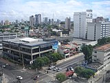
 Manaus
 -
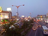
 Belém
Belém -
 Porto Velho
 -
 Ananindeua


Economy
changeThe economy of the North Region is essentially based on the plantations and the use of natural resources, such as latex, açaí, woods and nuts; and mineral extraction of gold, cassiterite and tin (metal); as well as mining exploitation, mainly iron in Pará and manganese in Amapá.
References
change- ↑ "Geociências: IBGE revê as altitudes de sete pontos culminantes" [Geosciences: IBGE revises the altitude of seven high points] (Press release) (in Portuguese). Brasília: Brazilian Institute of Geography and Statistics (IBGE). 29 February 2016. Archived from the original on 2 August 2017. Retrieved 18 February 2017.
- ↑ "Pico da Neblina, Brazil". Peakbagger.com. Retrieved 18 February 2017.
- ↑ "Brazil State High Points". Peakbagger.com. Retrieved 18 February 2017.
- ↑ 4.0 4.1 4.2 "Estimativas da População Residente no Brasil e Unidades da Federaçã com Data de Referencia en 1o de julho de 2016" (PDF) (in Portuguese). Instituto Brasileiro de Geografia e Estatística (IBGE). Retrieved 18 January 2017.