Vichy
Vichy (Occitan: Vichèi) is a commune in central France, in the Auvergne-Rhône-Alpes region, along the Allier river. It is the commune in the department with second largest population after Montluçon. It is in the historic province of Bourbonnais.
Vichy | |
|---|---|
.jpg) Vichy and the Aller river. | |
 Coat of arms | |
Location of Vichy  | |
 Vichy  Vichy | |
| Coordinates: 46°07′40″N 3°25′36″E / 46.1278°N 3.4267°E | |
| Country | France |
| Region | Auvergne-Rhône-Alpes |
| Department | Allier |
| Arrondissement | Vichy |
| Canton | Chief town of 2 cantons: * Vichy-1 * Vichy-2 |
| Intercommunality | Vichy Communauté |
| Government | |
| • Mayor (2014-2020) | Claude Malhuret |
| Area 1 | 5.85 km2 (2.26 sq mi) |
| Population (2014) | 25,279 |
| • Density | 4,300/km2 (11,000/sq mi) |
| Demonym | Vichyssois |
| Time zone | UTC+01:00 (CET) |
| • Summer (DST) | UTC+02:00 (CEST) |
| INSEE/Postal code | 03310 /03200 |
| Elevation | 243–317 m (797–1,040 ft) (avg. 280 m or 920 ft) |
| Website | www.ville-vichy.fr |
| 1 French Land Register data, which excludes lakes, ponds, glaciers > 1 km2 (0.386 sq mi or 247 acres) and river estuaries. | |
History
changeVichy has lots of Spas and resorts. This site was inhabited before the Roman conquest of Gaul.[1]
In 1861, Napoleon III visited Vichy several times.[2]
During World War II, it was the capital city of Vichy France.[3]
Geography
changeThe commune of Vichy is on the southern part of the Allier department. The city is on the right side of the Allier river.
The commune has an area of 5.9 km2 (2.3 sq mi),[4] and its average altitude is 280 m (920 ft); at the city hall, the altitude is 268 m (879 ft).[5]
The distances from Vichy to other cities are:
- Paris, the national capital - 406 km (252 mi);
- Lyon, the regional capital - 164 km (102 mi);
- Reims - 481 km (299 mi);
- Bordeaux - 417 km (259 mi);
- Toulouse - 418 km (260 mi);
- Montpellier - 395 km (245 mi);
- Strasbourg - 528 km (328 mi);
- Nantes - 520 km (320 mi);
- Marseille - 474 km (295 mi).

|
Vichy is surrounded by the communes Creuzier-le-Vieux, Cusset, Le Vernet, Abrest, Bellerive-sur-Allier and Charmeil.
Climate
changeThe Köppen climate classification type for the climate at Vichy is an "Oceanic climate" (also known as Maritime Temperate climate) and of the subtype "Cfb".[6]
Population
changeThe inhabitants of Vichy are known, in French, as Vichyssois (women: Vichyssoises).[7]
With a population of 25,279,[8] Vichy is the second largest city of the Allier department. It has a population density of 4,321 inhabitants/km2.
Evolution of the population in Vichy

Administration
changeVichy is a subprefecture of the Allier department since 1941; before that year, the subprefecture was in Lapalisse. It is also the capital of the arrondissement of Vichy and the administrative centre (French: chef-lieu) of two cantons:
- Vichy-1 formed by 3 communes and part of Vichy, with 18,420 inhabitants (2014).
- Vichy-2 formed by 2 communes and part of Vichy, with 18,763 inhabitants (2014).
It is part of the intercommunality Vichy Communauté.
Sister cities
changeGallery
change-
 City hall of Vichy.
 -
 Rue de l'hôtel des postes, pedestrian street.
 -
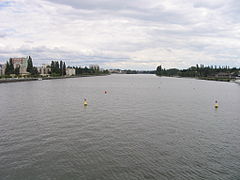 The Allier river in Vichy.
 -
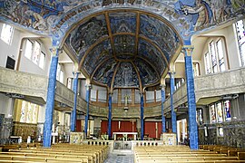 Saint-Blaise church, Vichy.
 -
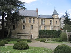 Castel Franc, Vichy.


Related pages
changeReferences
change- ↑ Gros, J.F. (1884). "Vichy in History," Vichy and environs, pp. 83-54.
- ↑ Prince, Danforth et al. (2011). Frommer's France, p. 473.
- ↑ Vinen, Richard. (2007). The Unfree French: Life Under the Occupation, p. 45.
- ↑ "Commune de Vichy (03310)". Comparateur de territoire (in French). Institut national de la statistique et des études économiques - INSEE. Retrieved 24 September 2017.
- ↑ "Vichy". Map-France.com. Retrieved 24 September 2017.
- ↑ Cite error: The named reference
mairiewas used but no text was provided for refs named (see the help page). - ↑ "Allier" (in French). habitants.fr. Retrieved 24 September 2017.
- ↑ "Régions, départements, arrondissements, cantons et communes" (PDF). Populations légales 2014 (in French). Institut national de la statistique et des études économiques - INSEE. Retrieved 24 September 2017.
- ↑ "Jumelage" (in French). Ville de Vichy. Retrieved 24 December 2017.