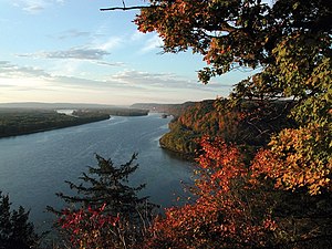
Mississippi River
The Mississippi River is a river in the United States. It is the 11th longest river in the world. Its largest city is Memphis, Tennessee.
| Mississippi River | |
|---|---|
 Mississippi River near Fire Point in Effigy Mounds National Monument, Iowa | |
 Mississippi River basin | |
| Etymology | Ojibwe word misi-ziibi, meaning "Great River", or gichi-ziibi, meaning "Big River" |
| Location | |
| Country | United States |
| State | Minnesota, Wisconsin, Iowa, Illinois, Missouri, Kentucky, Tennessee, Arkansas, Mississippi, Louisiana |
| Cities | Saint Cloud, MN, Minneapolis, MN, St. Paul, MN, La Crosse, WI, Quad Cities, IA/IL, St. Louis, MO, Memphis, TN, Baton Rouge, LA, New Orleans, LA |
| Physical characteristics | |
| Source | Lake Itasca[1] |
| - location | Itasca State Park, Clearwater County, MN |
| - coordinates | 47°14′23″N 95°12′27″W / 47.23972°N 95.20750°W |
| - elevation | 1,475 ft (450 m) |
| Mouth | Gulf of Mexico |
| - location | Pilottown, Plaquemines Parish, LA |
| - coordinates | 29°09′04″N 89°15′12″W / 29.15111°N 89.25333°W |
| - elevation | 0 ft (0 m) |
| Length | 2,320 mi (3,730 km) |
| Basin size | 1,151,000 sq mi (2,980,000 km2) |
| Discharge | |
| - location | mouth; max and min at Baton Rouge, LA[2] |
| - average | 593,000 cu ft/s (16,800 m3/s)[2] |
| - minimum | 159,000 cu ft/s (4,500 m3/s) |
| - maximum | 3,065,000 cu ft/s (86,800 m3/s) |
| Discharge | |
| - location | St. Louis[3] |
| - average | 168,000 cu ft/s (4,800 m3/s)[3] |
| Basin features | |
| Tributaries | |
| - left | St. Croix River, Wisconsin River, Rock River, Illinois River, Kaskaskia River, Ohio River |
| - right | Minnesota River, Des Moines River, Missouri River, White River, Arkansas River |

The name "Mississippi" comes from a Native American name that means "big river". The source of the Mississippi is Lake Itasca in Minnesota, near the border with Canada. The Mississippi flows south through the middle of the United States. It flows through the states of Minnesota, Wisconsin, Iowa, Illinois, Missouri, Kentucky, Tennessee, Arkansas, and Mississippi. The mouth of the Mississippi is in the state of Louisiana, south of the city of New Orleans. The Mississippi flows into the Gulf of Mexico.
At the end of the Mississippi there is a zone in the Gulf of Mexico where very few animals can survive comfortably because of the fertilizer and other chemicals that run off of farms into the river and its tributaries. The rivers then carry them into the gulf.[4]
Transportation
changeThe Mississippi has been very important for transportation in the history of the United States. In the 1800s, many steamboats traveled on the Mississippi River. St. Louis, Missouri, Memphis, Tennessee, and New Orleans were important port cities.
Tributaries
changeThe Mississippi has many large tributaries, or rivers that flow into it. The watershed of the Mississippi covers much of the United States. This means that the Mississippi and its tributaries drain much of the United States.
Some important tributaries of the Mississippi are (listed from the source to the mouth of the river):
| River |
|---|
| the Minnesota River |
| the St. Croix River |
| the Wisconsin River |
| the Illinois River |
| the Missouri River |
| the Ohio River |
| the Arkansas River |
The Mississippi River in books
changeA big part of the book Huckleberry Finn by Mark Twain is set on the Mississippi River. Twain also wrote a book called Life on the Mississippi, which had some stories about how he used to work on a steamboat.
References
change- ↑ The United States Geological Survey recognizes two contrasting definitions of a river's source.USGS.gov By the stricter definition, the Mississippi would share its source with its longest tributary, the Missouri, at Brower's Spring in Montana. The other definition acknowledges "somewhat arbitrary decisions" and places the Mississippi's source at Lake Itasca, which is publicly accepted as the source,USGS.gov and which had been identified as such by Brower himself.MT.gov Archived 2012-01-18 at the Wayback Machine
- ↑ 2.0 2.1 Kammerer, J.C. (May 1990). "Largest Rivers in the United States". U.S. Geological Survey. Retrieved February 22, 2011.
- ↑ 3.0 3.1 Median of the 14,610 daily streamflows recorded by the USGS for the period 1967–2006.
- ↑ "Hypoxic zone-USGS". Archived from the original on 2008-03-04. Retrieved 2008-02-17.