Syria
Syria | |
|---|---|
_-_SYR_-_UNOCHA.svg) | |
| Capital and largest city | Damascus 33°30′N 36°18′E / 33.500°N 36.300°E |
| Recognised languages | |
| Major languages | Arabic Kurdish |
| Minor languages | Syriac Aramaic Armenian Circassian Turkish French English |
| Ethnic groups (2014[5]) | 90% Arab 9% Kurd 1% Other |
| Religion | 87% Islam 2% Christianity[6] 3% Druze[7] |
| Demonym(s) | Syrian |
| Government | |
| Abu Mohammed Al-Julani | |
| Mohammed al-Bashir | |
| Legislature | Vacant |
| Establishment | |
• Arab Kingdom of Syria | 8 March 1920 |
• State of Syria under French mandate | 1 December 1924 |
• Syrian Republic | 14 May 1930 |
• De jure Independence | 24 October 1945 |
• De facto Independence | 17 April 1946 |
• Left the United Arab Republic | 28 September 1961 |
• Ba'ath party seized power | 8 March 1963 |
| 8 December 2024 | |
| Area | |
• Total | 185,180[8] km2 (71,500 sq mi) (87th) |
• Water (%) | 1.1 |
| Population | |
• 2020 estimate | 17,500,657 (66th) |
• 2010 census | 21,018,834 |
• Density | 118.3/km2 (306.4/sq mi) (70th) |
| GDP (PPP) | 2015 estimate |
• Total | $50.28 billion[6] |
• Per capita | $2,900[6] |
| GDP (nominal) | 2014 estimate |
• Total | $24.6 billion[6] (167) |
• Per capita | $831[6] |
| Gini (2014) | 55.8[9] high |
| HDI (2019) | medium · 151st |
| Currency | Syrian pound (SYP) |
| Time zone | UTC+2 (EET) |
• Summer (DST) | UTC+3 (EEST) |
| Driving side | right |
| Calling code | +963 |
| ISO 3166 code | SY |
| Internet TLD | .sy سوريا. |

.svg)
.svg)
Syria is a country in the Middle East, the west part of Asia. It borders Turkey, Lebanon, Jordan, Iraq and Palestine. Its western part faces the Mediterranean Sea and shares a maritime border with Cyprus, while its eastern and northern parts are mountainous. Syria's national capital is Damascus.
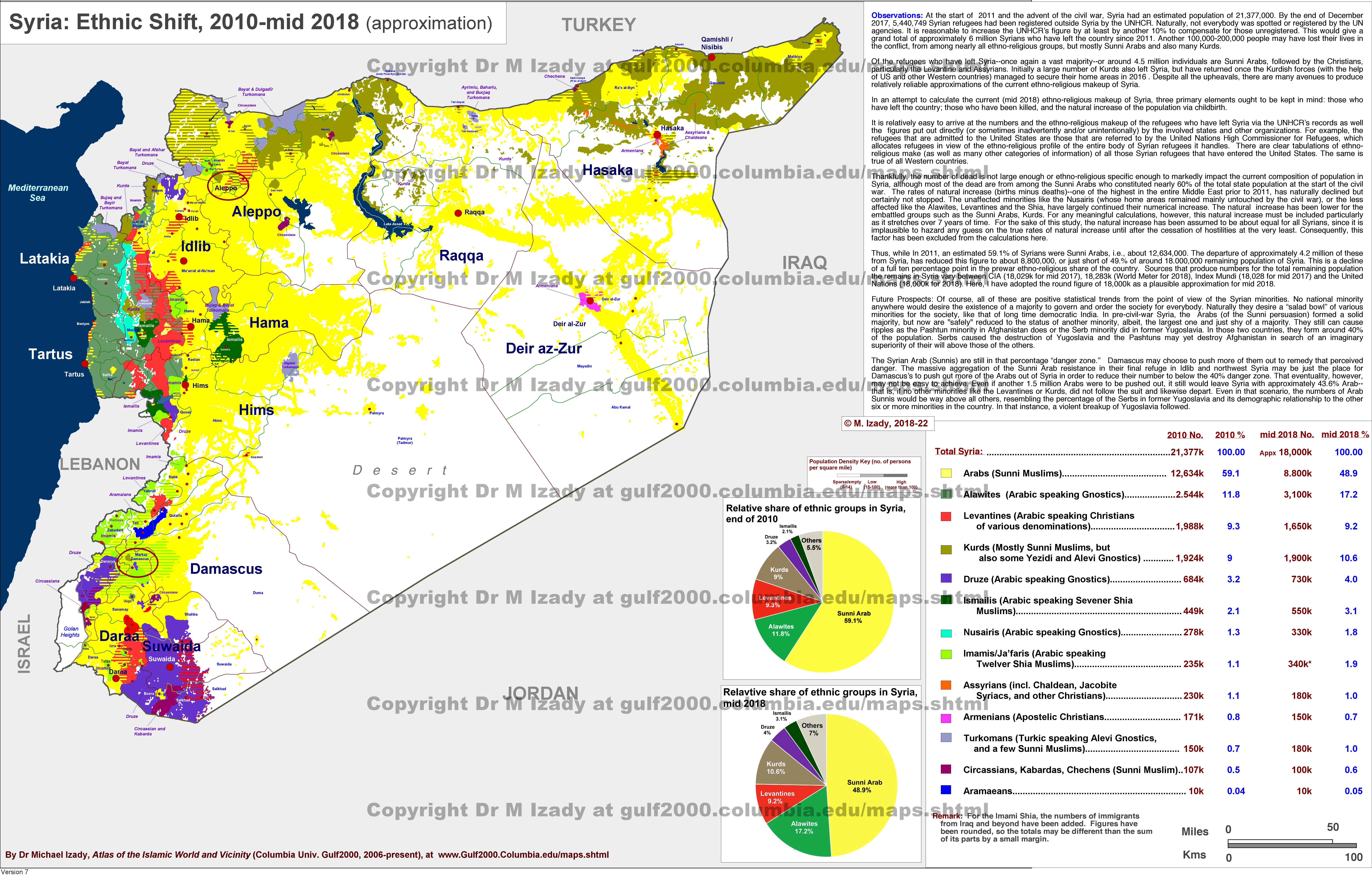
The biggest city is Aleppo. It has been embroiled in civil war since March 2011, when the population of Syria was 74% Sunni, 12% Alawi Shia, 10% Christian, 3% Druze, 1% Ismaili Shia 0.4% Twelver Shia and 0.1% Yazidi.[11]
History
changeBefore 20th century
changeSyria has a very long history. It was a land of Phoenicians, which then became part of the Achaemenid Empire, Roman Empire, and then the Eastern Roman Empire. In those days people in Syria spoke the Syriac language and used the Syriac alphabet, while the Syrian city Antioch was one of the important cities in Christendom.
Islamization
changeThe Umayyad Caliphate took over Syria from the Eastern Roman Empire in the 7th century. Most of the indigenous population was converted to Islam and adopted the Arabic language.[12]
20th century
changeWhen World War I started, the Ottoman Empire ruled Syria and many other places. When it ended, France controlled Lebanon and Syria. Britain had Iraq, Jordan and Palestine. They drew a border between Iraq and Syria in 1920. France controlled Syria until 1946 when Syria became its own country.[13][better source needed]
Cold War
change
Syria was part of the United Arab Republic with Egypt between 1958 and 1961. Syria fought some wars with Israel. Its former territory Golan Heights has been governed by Israel since 1967.[14]
Meanwhile, the Ba'athist party seized power with a coup in 1963 to establish a junta.[15][16] In 1970, Hafiz al-Assad, the father of Bashar al-Assad, took over with another coup and turned the Ba'athist Syrian state into a dynastic totalitarian state,[15][16] featured by systematic oppression and widespread human rights abuses,[15][16] which was passed on to Bashar when Hafiz passed away in 2000.[15][16]
21st century
changeMost Syrians believe in Islam, while an ethnoreligious Christian minority, called the Syriac Christians, exists.[17]
2010s
changeIn 2011, anti-regime protests were brutally suppressed by President Bashar al-Assad, sparking off a civil war against Assad. Assad went on to commit countless atrocities against Syrians, including massacres, starving sieges[18] and chemical attacks,[19][20] which killed over 400,000 Syrians.[19][20] Amid the war, the Kurds took over a sizeable part of northern Syria, namely the Rojava.[21] In 2016, Assad regained most of Syria with the superior firepower of Russia and Iran.[22]
2020s
changeA myriad of factors, including the COVID-19 pandemic[23] and pro-Russian Western leftist opposition to NATO intervention,[24][25] had made the civil war a frozen conflict for several years until December 2024.[26]
In December 2024, regrouped rebel forces launched large-scale multi-pronged offensives unseen for a decade[26] amid weakened local Russian and Iranian military presence,[27] reportedly due to the countries' respective involvement in the invasion of Ukraine and conflict with Israel.[26][27] Aleppo, Homs and Daraa,[28] three of the largest Syrian cities, fell to the rebels within a week,[26] who also encircled Syria's capital Damascus.[26][29]
Fall of Ba'athist rule
changeOn December 8, 2024, Bashar al-Assad fled the capital as the rebels stormed in.[30] Assad's protecting power Russia claimed that Assad had left Syria[31] for Moscow.[32] Rebels inside the capital announced the end of the six-decade Ba'athist rule in Syria.[31][33]
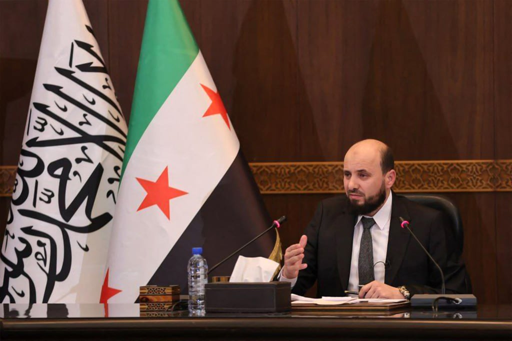
Transitional government
changeThe united opposition announced that Mohammed al-Bashir, a previous leader of the provisional Salvation Government in Turkish-controlled northwest Syria, was named as the head of the transitional government, expected to serve until March 2025.[34]
Geography
changeSyria is between latitudes 32° and 38° N, and longitudes 35° and 43° E. It is mostly arid plateau. The area bordering the Mediterranean is fairly green. The Euphrates, Syria's most important river, crosses the country in the east. The climate in Syria is dry and hot. Winters are mild.[source?]
Politics and government
changeSyria is a republic. The old Constitution of Syria was started on 13 March 1971,[35][better source needed] making Syria a de jure secular socialist state. Islam was the majority religion. A new constitution has been in place since 2012.[source?]
Branches of government
changeThe executive branch is the president, two vice presidents, the prime minister, and the Council of Ministers. The constitution says the president must be a Muslim.[35] It does not make Islam the state religion. According to the 2012 constitution, the president is elected by the Syrian people in a direct election. The People's Council is the legislative branch.[better source needed]
State control
changeNearly all of Syria’s radio and television outlets are state owned. The Ba'ath Party controls nearly all newspapers.[36][better source needed]
Human rights
changeSyria's human rights are among the worst in the world, according to human rights organizations such as Human Rights Watch.[37][better source needed] The authorities kidnap democracy and human rights activists, censor websites and impose travel bans on their targets.[source?]
Military
changeThe President of Syria is commander in chief of the Syrian armed forces. There are about 400,000 troops. Ethnic Kurds have their own army called YPG. The Males must go in the military when they are age 18.[38] The armed forces stood down with the fall of the Ba'athist rule on December 8, 2024.[31][33]
Governorates
changeSyria has fourteen Governorates, or muhafazat. The governorates are divided into sixty districts. The governorates are:
Economy
changeSyria is a middle-income country. The economy is based on agriculture, oil, industry and tourism.[source?]
Transport
changeSyria has three international airports (Damascus, Aleppo and Lattakia). They are hubs for Syrian Air. Foreign airlines also fly to them.[39][better source needed] Most Syrian cargo is carried by Chemins de Fer Syriens, the Syrian railway company.[source?]
Demographics
change| Population in Syria[40][41] | |||
|---|---|---|---|
| Year | Million | ||
| 1971 | 6.6 | ||
| 1990 | 12.7 | ||
| 2009 | 21.9 | ||
| Source: OECD/World Bank/UNO | |||
Most people live in the Euphrates valley and along the coastal plain, a fertile strip between the coastal mountains and the desert. Education is free from ages 6 to 12. All children this age must attend school.[source?]
Sports
changeThe most popular sports in Syria are football, basketball, swimming, and tennis. Damascus was home to the fifth and seventh Pan Arab Games. Many popular football teams are based in Damascus, Aleppo, Homs, and Latakia.[source?]
Related pages
changeReferences
change- ↑ "Archived copy". Archived from the original on 12 December 2024. Retrieved 13 December 2024.
{{cite web}}: CS1 maint: archived copy as title (link) - ↑ https://img.i-scmp.com/cdn-cgi/image/fit=contain,width=1024,format=auto/sites/default/files/d8/images/canvas/2024/12/11/951bec6e-d1e6-4c8c-a69b-940a212eec9e_595de0ff.jpg
- ↑ https://edition.cnn.com/2024/12/06/world/video/abu-mohammad-al-jolani-syria-rebel-leader-karadsheh-digvid
- ↑ https://www.lbcgroup.tv/news/middleeastnews/823325/mohammed-al-bashir-appointed-caretaker-syrian-pm-for-transitional-gove/en
- ↑ "Syria". CIA World factbook. CIA. Archived from the original on 24 June 2014.
- ↑ 6.0 6.1 6.2 6.3 6.4 "Syria". The World Factbook. Central Intelligence Agency. Retrieved 7 April 2021.
- ↑ "Syria: Ethnic Shift, 2010–mid 2018". gulf2000.columbia.edu. Columbia University Gulf2000. 2018. Retrieved 2 June 2019.
- ↑ "Syrian ministry of foreign affairs". Archived from the original on 11 May 2012.
- ↑ "World Bank GINI index". World Bank. Retrieved 22 January 2013.
- ↑ Human Development Report 2020 The Next Frontier: Human Development and the Anthropocene (PDF). United Nations Development Programme. 15 December 2020. pp. 343–346. ISBN 978-92-1-126442-5. Retrieved 16 December 2020.
- ↑ "Religion in Syria - 1943 Syrian Census". Retrieved 8 January 2024.
- ↑
- Hawting, G. R. (2001). "The First Dynasty of Islam". The Umayyad Caliphate AD 661-750 (2 ed.). London: Routledge. doi:10.4324/9780203137000. ISBN 9780203137000. Retrieved 8 December 2024.
- Carlson, Thomas A. (2015). "Contours of Conversion: The Geography of Islamization in Syria, 600–1500". Journal of the American Oriental Society. 135 (4 (October–December 2015)). American Oriental Society: 791–816. doi:10.7817/jameroriesoci.135.4.791. JSTOR 10.7817/jameroriesoci.135.4.791. Retrieved 8 December 2024.
- Tomass, Mark (2016). "The Islamization of the Fertile Crescent". The Religious Roots of the Syrian Conflict. pp. 97–106. Retrieved 8 December 2024.
- Penn, Michael (2018). "Early Syriac Reactions to the Rise of Islam". The Syriac World (1 ed.). Routledge. ISBN 9781315708195. Retrieved 8 December 2024.
- Furman, Yulia; Cherkashin, Dmitry (10 October 2024). ""Superiority is due to us, and the king should come from among us": The Arab Conquests and Conflicts of the Early Umayyad Era in a 7th-Century Syriac Universal History of Yoḥannān bar Penkāyē". Der Islam. 101 (2). De Gruyter. doi:10.1515/islam-2024-0020. Retrieved 8 December 2024.
- ↑ "Report of the Commission Entrusted by the Council with the Study of the Frontier between Syria and Iraq". World Digital Library. 1932. Retrieved 11 July 2013.
- ↑
- Al-Makahleh, Shehab (24 July 2018). "Jordan Navigates Border Trade, Pressures from Syria". The Washington Institute. Retrieved 8 December 2024.
- Regev, Mark (9 June 2023). "The Six Day War: Six fateful days for Israel in 1967 - opinion". The Jerusalem Post. Retrieved 8 December 2024.
- Katz, Mark N. (12 September 2024). "The Soviet Roots of Putin's Foreign Policy Toward the Middle East". Carnegie Endowment for International Peace. Retrieved 8 December 2024.
Despite the dichotomy between ideological, Soviet-era support for anti-Western regimes and interest-driven Putin-era support, there are several similarities.
- ↑ 15.0 15.1 15.2 15.3
- Gilbert, Victoria J. (2013). "Syria for the Syrians: The rise of Syrian nationalism, 1970-2013". ProQuest. Northeastern University, Boston, Massachusetts. Retrieved 9 December 2024.
- Giesbers, A.M.K. (2018). "Ba'athism: the hidden hand behind ISIS? An examination of the Ba'ath ideology, Saddam-regime and ISIS". Utrecht University. Retrieved 9 December 2024.
- McBride, Megan K. (28 May 2019). "Unforced Errors: ISIS, The Baath Party, And The Reconciliation Of The Religious and The Secular". Politics, Religion & Ideology. 20 (2): 170–191. doi:10.1080/21567689.2019.1617136. Retrieved 9 December 2024.
- Utchel, Donald M. (2019). "The Parallel Security Apparatus: Examining the Cases of Baathist Iraq, Syria, and Iran". ProQuest. University of Nevada, Las Vegas. Retrieved 9 December 2024.
- Zaamout, Noureddin Mahmoud (2023). "The Spirit of an Uprising: Contentious Politics and Pluralism in Syrian Society Post Arab Spring". Education & Research Archive. doi:10.7939/r3-4g03-jt64. Retrieved 9 December 2024.
- ↑ 16.0 16.1 16.2 16.3
- Mobaied, Samira (2020). "The Baatho-Assadist System, a System of Political Instrumentalisation". Open Journal of Political Science. 10 (1). Paris, France: 124–133. doi:10.4236/ojps.2020.101009. Retrieved 9 December 2024.
{{cite journal}}: CS1 maint: unflagged free DOI (link) - "Bashar al-Assad - Syrian Conflict, Dictatorship, Human Rights". Britannica. 9 December 2024.
- "'Totalitarian Regimes rarely fall peacefully, it is a Matter of long Preparations'". Sarajevo Times. 9 December 2024.
- AFP - Agence France Presse (6 December 2024). "Syria's Bashar Al-Assad's Quarter Century In Power". Barron's. Retrieved 9 December 2024.
- Williams, Zoe (9 December 2024). "They 'didn't look the type': how the media was fooled by Bashar and Asma al-Assad". The Guardian.
- Mobaied, Samira (2020). "The Baatho-Assadist System, a System of Political Instrumentalisation". Open Journal of Political Science. 10 (1). Paris, France: 124–133. doi:10.4236/ojps.2020.101009. Retrieved 9 December 2024.
- ↑
- Parry, Ken (4 July 2007). The Blackwell Companion to Eastern Christianity. doi:10.1002/9780470690208. ISBN 9780470690208. Retrieved 8 December 2024.
- Jasser, M. Zuhdi (2014). "Sectarian Conflict in Syria". PRISM. 4 (Syria Supplement): 58–67. JSTOR 26469777. Retrieved 8 December 2024.
- Rousseau, Eliott (13 May 2014). "The Construction of Ethnoreligious Identity Groups in Syria: Loyalties and Tensions in the Syrian Civil War". Bridgewater State University. Retrieved 8 December 2024.
- Besenyő, János; Gömöri, Roland (2015). "Christians in Syria and the civil war" (PDF). Retrieved 8 December 2024.
- Butts, Aaron Michael; Gross, Simcha (2020). "XII". Jews and Syriac Christians: Intersections across the First Millennium Edited by Aaron Michael Butts and Simcha Gross (Juden und syrische Christen. Schnittstellen im ersten Jahrtausend). Retrieved 8 December 2024.
- ↑
- "The Failure to Stop Starvation Tactics in Syria". Carnegie Endowment for International Peace. 2014. Retrieved 8 December 2024.
- "Syria: Assad forces 'using starvation as weapon of war'". BBC News. 10 March 2014. Retrieved 8 December 2024.
- Gillard, Emanuela-Chiara (2020). "Seventy Years of the Geneva Conventions". Chatham House. Retrieved 8 December 2024.
- "Assad regime's starve or surrender strategy 'a crime against humanity'". The Guardian. 13 November 2017. Retrieved 8 December 2024.
- "Syria". Starvation Accountability. Retrieved 8 December 2024.
- ↑ 19.0 19.1
- al-Labwani, Mohamad Kamal (11 February 2021). "The UN Process and the War Crimes of Assad". The Washington Institute. Retrieved 7 December 2024.
- "The evidence of Syrian President Bashar Assad and his regime's legacy of war crimes". CBS News. 11 July 2021. Retrieved 7 December 2024.
- "The Case Against Assad". Hoover Institution. 6 September 2022. Retrieved 7 December 2024.
- "French court issues arrest warrant for Bashar al-Assad for complicity in war crimes". The Guardian. 15 November 2023. Retrieved 7 December 2024.
- ""Bashar Al-Assad is guilty of war crimes" - France ONU". France ONU. Retrieved 7 December 2024.
- ↑ 20.0 20.1
- Baker, Elise (25 May 2023). "How to hold the Assad regime accountable, even as countries normalize relations with Syria". Atlantic Council. Retrieved 8 December 2024.
- "Syria: The Impunity of the Assad Regime Must Never be Normalized". United States Holocaust Memorial Museum (USHMM). 12 July 2023. Retrieved 8 December 2024.
- "France issues arrest warrant for Syria's President Assad over alleged war crimes". Sky News. 16 November 2023. Retrieved 8 December 2024.
- "First indictment in Belgium for war crimes under Assad's regime in Syria". Commission for International Justice and Accountability. 29 January 2024. Retrieved 8 December 2024.
- "Syria". Global Centre for the Responsibility to Protect. 1 December 2024. Retrieved 8 December 2024.
- ↑
- Schiffmann, Michael (2018). Rojava: Revolution, War and the Future of Syria's Kurds. Pluto Press. doi:10.2307/j.ctv1qv2bm. JSTOR j.ctv1qv2bm. Retrieved 7 December 2024.
- Kemerli, Pınar (2023). "Revolutionary Self-Defense as a Rival Ethics of Nonviolence: Rojava and Kurdish Liberation". Violence: A Reappraisal (1 ed.). Routledge. ISBN 9781003379898. Retrieved 7 December 2024.
- Macmillan-Scott, Olivia; Ünver, Akin; Musolesi, Mirco (5 June 2024). "Game-theoretic agent-based modelling of micro-level conflict: Evidence from the ISIS-Kurdish war". Plos one. Retrieved 7 December 2024.
- Brawley, Laura (5 June 2024). "Reconstruction in the Midst of Rebellion: A Kurdish Case Study of Gender, Militancy, and Ideology in the MENA Region". Tulane Undergraduate Research Journal. 5 (1). Retrieved 7 December 2024.
- Corradi, Edoardo; Cama, Giampiero (7 November 2024). "Institutions, power-sharing, and the cohesiveness of rebel coalitions in the Syrian civil war". Small Wars & Insurgencies. doi:10.1080/09592318.2024.2424055. Retrieved 7 December 2024.
- ↑
- Collard, Rebecca (16 August 2018). "Idlib Could Be the Last Major Battlefield of the Syrian Civil War. But Assad Won't Take It Easily". Times Magazine. Retrieved 7 December 2024.
- "Idlib: 'I cried so much when we heard the warplanes again'". BBC News. 12 September 2018. Retrieved 7 December 2024.
- "Millions of Syrians at risk if Idlib truce fails, White Helmets warn". The Guardian. 3 November 2018. Retrieved 7 December 2024.
- "Russian Sieges of Ukrainian Cities Provoke Bitter Recollections for Syrians (Published 2022)". The New York Times. 11 March 2022. Retrieved 7 December 2024.
- Tokmajyan, Armenak (3 October 2023). "Tormented Territory: The Emergence of a De Facto Canton in Northwestern Syria". Carnegie Endowment for International Peace. Retrieved 7 December 2024.
- ↑
- Qaddour, Amany; Fallon, Kat (18 February 2021). "Covid-19: Compounding 10 Years of Health Crises in Syria". Center for Strategic and International Studies. Retrieved 8 December 2024.
- Daw, Mohamed A. (11 June 2021). "The Impact of Armed Conflict on the Epidemiological Situation of COVID-19 in Libya, Syria and Yemen". Frontiers in Public Health. 9. Retrieved 8 December 2024.
- "World News in Brief: Hostilities in Syria, Israeli detention practices, 'summer wave of COVID-19' in Europe". 8 August 2024. Retrieved 8 December 2024.
- ↑
- al-Haj Saleh, Yassin (11 September 2015). "Syria and the Left". Centre tricontinental. Retrieved 8 December 2024.
- Győri, Lóránt; Krekó, Péter (13 June 2016). "Don't ignore the left! Connections between Europe's radical left and Russia". openDemocracy. Retrieved 8 December 2024.
- "How do you recognise an Assadist?". Critical Legal Thinking. 24 August 2016. Retrieved 8 December 2024.
- Sandlin, Evan (30 October 2016). "Dereliction of Duty? The Left and the Syrian Civil War". Los Angeles Review of Books. Retrieved 8 December 2024.
- Lucas, Scott (1 November 2016). "Syria Opinion: How the Left Betrayed the Syrian Uprising". EA WorldView. Retrieved 8 December 2024.
- ↑
- Monbiot, George (2 March 2022). "We must confront Russian propaganda – even when it comes from those we respect". The Guardian. Retrieved 8 December 2024.
- Al Yafai, Faisal (18 March 2022). "Two Prominent Leftist Writers Split on Syria's War". New Lines Magazine. Retrieved 8 December 2024.
- La Botz, Dan (2022). "Internationalism, Anti-Imperialism, And the Origins of Campism". New Politics. Vol. XVIII, no. 4. Retrieved 8 December 2024.
- Naffakh, Mahmoud (2 March 2023). "How 'apolitical' Western Youtubers help push Syrian propaganda". The France 24 Observers. Retrieved 8 December 2024.
- Ayoub, Elia J (25 August 2024). "Left analyses of imperialism must stand against 'campism'". Red Pepper Magazine. Retrieved 8 December 2024.
- ↑ 26.0 26.1 26.2 26.3 26.4
- "Rebel forces 'reach Damascus suburbs' as protesters topple statue on outskirts". Sky News. 7 December 2024.
- "Faced with a new rebel offensive, can Bashir al-Assad survive in Syria?". New York Post. 7 December 2024.
- "Syria rebels say they encircle Damascus; West said expecting regime's fall within days". The Times of Israel. 7 December 2024.
- "Syria Civil War: What to Know About the Conflict and the Rebel Groups". The New York Times. 7 December 2024.
- "Syrian rebels claim control of key city of Homs, opening path to Damascus". The Guardian. 7 December 2024.
- ↑ 27.0 27.1
- "Fall of Aleppo deals blow to Russia's Middle East clout, may indirectly strengthen Ukraine's hand". The Kyiv Independent. 3 December 2024. Retrieved 8 December 2024.
- Cook, Steven A. (5 December 2024). "What Syria's Revived Civil War Means for the Region". Council on Foreign Relations. Retrieved 8 December 2024.
- Professor Christopher Phillips (6 December 2024). "What next for Syria, Assad and HTS?". Chatham House. Retrieved 8 December 2024.
- "Iran Update, December 6, 2024". Institute for the Study of War (ISW). 6 December 2024. Retrieved 8 December 2024.
- "As Assad Prepares Last Stand, His Ally Iraq Rules Out Military Intervention". Newsweek. 7 December 2024. Retrieved 8 December 2024.
- ↑
- "Syrian rebels claim control of Daraa, demolish Assad monument – video". Ukrainska Pravda. 7 December 2024. Retrieved 8 December 2024.
- "Syria updates: Rebel forces begin to enter city of Homs". DW News. 7 December 2024. Retrieved 8 December 2024.
- "Syrian protesters topple Hafez al-Assad statue, residents and activists say". Reuters. 7 December 2024. Retrieved 8 December 2024.
- "What was behind Daraa's rapid fall, and did HTS participate?". Syria Direct. 7 December 2024. Retrieved 8 December 2024.
- "Syrian rebels claim to have taken control of key Daraa city". News.Az. 7 December 2024. Retrieved 8 December 2024.
- ↑
- "Syria war: Assad regime on brink as rebels begin to encircle Damascus". The Telegraph. 7 December 2024. Retrieved 8 December 2024.
- "Syrian rebels push towards Damascus as Assad's grip on power wanes". Financial Times (FT). 8 December 2024.
- "'He has come out an old man': joy and grief as loved ones released from Assad prisons". The Guardian. 7 December 2024. Retrieved 8 December 2024.
- "Syrian rebels make further inroads in major cities". NPR. 7 December 2024. Retrieved 8 December 2024.
- "What is happening in Syria and who is involved?". ITVX. 7 December 2024. Retrieved 8 December 2024.
- ↑
- "Syrian rebels say they have begun entering the capital Damascus". The Jerusalem Post. 8 December 2024.
- "Syrian opposition war monitor says President Bashar Assad has left the country to an undisclosed location". ABC News. 8 December 2024.
- "Assad has left Damascus, senior army officers say; Syria rebels say they are in capital". Reuters. 8 December 2024.
- "War monitor says Assad fled Syria ahead of rebels entering the capital". Associated Press (AP). 8 December 2024.
- "Syrian dictator Bashar Assad flees into exile as Islamist rebels conquer country". Fox News. 8 December 2024.
- ↑ 31.0 31.1 31.2
- "Syrian rebels topple President Assad, Russia says he left the country". Reuters. 8 December 2024.
- "This is the Assad family, whose 54 year-regime has just ended". Ynetnews. 8 December 2024.
- "BREAKING: Syrian rebels announce fall of Russia-backed Assad regime". The Kyiv Independent. 8 December 2024.
- "After 14 years of conflict, Assad's fall brings an end to Syria's dynastic rule". Euronews. Retrieved 8 December 2024.
- "Bashar al-Assad reported to have fled Syria as rebels say they have captured Damascus". The Guardian. 8 December 2024.
- ↑
- "Ousted Syrian president Assad 'granted asylum' in Moscow - as world leaders hail end of 'barbaric' regime". Sky News. 8 December 2024.
- "Syria's Bashar al-Assad fled to Moscow, Kremlin says". Axios. 8 December 2024.
- "Russia grants asylum to exiled Assad, state media reports". Politico. 8 December 2024.
- "Assad flees to Moscow as Syrian rebels capture Damascus". CNN. 8 December 2024.
- "Steve Rosenberg: Fall of Assad is a blow to Russia's prestige". BBC News. 8 December 2024.
- ↑ 33.0 33.1
- "Assad regime falls and Syrian rebels capture Damascus". The Telegraph. 8 December 2024.
- "'Historic day,' says Netanyahu at Syrian border". Jewish News Syndicate (JNS). 8 December 2024.
- "Netanyahu claims credit for starting 'historic' process that led to Syrian regime's fall". The Times of Israel. 8 December 2024.
- "Israel deploys troops to Syrian border as Assad regime falls". The Jewish Chronicle. 8 December 2024.
- "Syria live: 'The future is ours' says Syrian rebel leader; Israel carries out airstrikes in Damascus, says report – latest updates". The Guardian. 8 December 2024.
- ↑
- "Syria Rebel Group Political Chief to Form Temporary Government". Bloomberg. 9 December 2024. Retrieved 10 December 2024.
- "With Syria's Assad gone, his PM agrees to hand power to rebel administration". Reuters. 10 December 2024.
- "Syria updates: Israeli military strikes Syrian army bases". DW News. 10 December 2024.
- "Rebel-backed figure takes charge as Syria's interim prime minister". CBC. 10 December 2024.
- "Syrian rebels name Mohammed al-Bashir head of transitional government". Le Monde. 10 December 2024.
- ↑ 35.0 35.1 "Constitution of Syria". Retrieved 22 October 2008.
- ↑ "Freedom House report on Syria (2010)" (PDF). Freedom House. Archived from the original (PDF) on 27 December 2010. Retrieved 20 May 2012.
- ↑ "Syria among worst for rights abuses: HRW report". Reuters. 24 January 2011. Archived from the original on 24 September 2015. Retrieved 31 August 2017.
- ↑ Syria – Overview. Retrieved 2010-02-01.
- ↑ "Syria – travel guides at Wikivoyage". Wikivoyage.org. Retrieved 26 March 2013.
- ↑ CO2 Emissions from Fuel Combustion Archived 2009-10-12 at the Wayback Machine Population 1971–2008 IEA pdf Archived 2012-01-06 at the Wayback Machine pages 83–85
- ↑ "UNData app". data.un.org. Retrieved 29 March 2022.